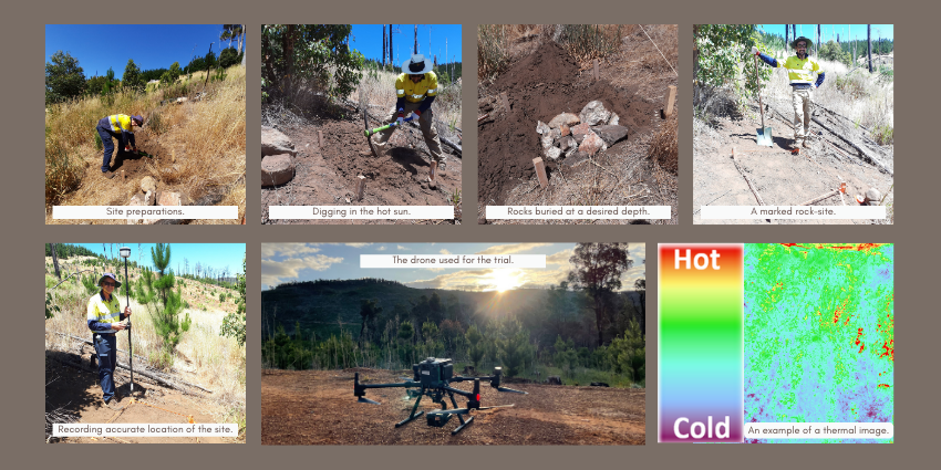
The FPC has begun preparations for a research trial to detect sub-surface or shallow rocks using remote sensing technologies.
The detection of sub-surface rocks is crucial in mitigating forest fire because they can pose a fire risk during harvesting operations when hit by the metal parts of a harvesting machine.
According to Dr. Irfan Iqbal, Remote Sensing Forester, “Identifying and mapping the location of sub-surface rocks will help us avoid these areas during harvesting operations in summertime and help mitigate the risk of forest fires which are a threat to our plantations and the wider community.”
“A drone with a thermal camera on board will be flown over the trial site to detect areas with sub-surface rocks. Thermal cameras are sensitive to the heat radiated by objects so in this case, it will pick up soil and rocks.
“Theoretically, the soil covering sub-surface rocks is likely to retain heat for relatively longer than the soil without sub-surface rocks. Thermal imaging close to sunset is expected to capture the temperature differences between the two. Our research trial is investigating this theory.”
Remote sensing technologies are increasingly being used in forest and timber plantation management to reduce the requirement of physical assessment, the time and effort involved, and validation when mapping vast areas.
The trial’s inception, which requires physically marking the known locations with sub-surface rocks to establish the baseline, is time and resource intensive.
In the interests of time and resource efficiency, rocks have been planted at different sites at three different depths of 5, 10, and 25 cm.
The various depths are chosen based on the experience that rocks at these depths are the most likely to be struck by harvesting machines, and it also tests the sensitivity of the thermal sensor to rocks at different depths.
Planting the rocks at known locations started a month before the trial to allow the sites to settle as close as possible to their natural state to boost the reliability and accuracy of the thermal imaging.
The ultimate aim of the trial is to map the distribution of naturally occurring sub-surface rocks with thermal remote sensing at all the FPC plantation sites.
The target areas will either be clear-felled sites or sites with trees no older than 1 to 2 years; otherwise, the thermal sensor will not be able to ‘see’ the ground under tree cover.
The mapping of sub-surface rocks will enable harvesting machines to avoid them and mitigate the risk of forest fire when harvesting occurs 30 years later or sometimes earlier during thinning operations.
“The work for the future has begun now, 30 years ahead of harvesting taking place. This is a testimony to our adoption of digital forestry and the application of science in our decision-making. It is our hope that this trial, if shared with the scientific community, will trigger a robust discussion that yields feedback or collaboration on similar trials in the future.” said Dr. Iqbal.