These are part of the wider suite of data standards for Western Australian government.
Address and high-level location standards guidance
The address standards are a collection of address components describing a specific physical location – usually a residential, postal, or business address.
The high-level location standards include broad location data elements, such as suburbs, postcodes, and local government areas.
The common reporting boundaries will see agencies reporting and sharing data using the same geographic basis in addition to their own boundaries.
Further reading on address standards
The AIHW standards for addressing rely on the Australian National Address Management Framework and AS4590 Interchange of client information Data elements and interchange formats. These are key resources if you require more detailed technical guidance on addressing.
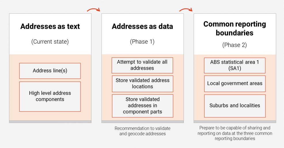
Phase 1: Addresses as data
High-level location standards
When collecting data using the high-level location standards, the options available for input should be drawn from the lists of permitted values. For example, by providing the authoritative list of suburbs on an online form.
Addresses as data
The first phase of implementation will see agencies moving from the practice of storing and sharing addresses as text to treating addresses as pieces of data. To achieve this:
- Addresses should be validated and geocoded as close as possible to the point of collection (new and upgraded data systems), and
-
addresses already collected should be retrospectively validated and geocoded (best effort basis).
Verification and geocoding
Transforming an address from text into data is a three step process.
These steps should all occur as close to the point of collection as possible - for example, directly on a web form. However this may not always be practical. In these cases, it should happen automatically as part of regular data ingest and cleaning processes.
- Attempt to validate the address
For example, using an address validation API that checks addresses against an authoritative datasets of Australian addresses. These APIs are widely available and are used by the 'as-you-type' address prediction fields commonly used on online forms. -
Geocode the validated address
Geocoding is the process of converting a validated addresses to a geographic location.
For example, '2 Havelock St, West Perth WA 6005' is converted to latitude and longitude coordinates '-31.952908, 115.843919' or its Geocoded National Address File (GNAF) identifier. -
Store the results of address validation and geocoding
The results of validation (the address in its components parts) and geocoding (coordinates or GNAF Ids) should both be stored alongside the address as separate data fields.
Handling addresses that cannot be validated
Not all locations have addresses that can be validated (e.g. Remote stations and communities) and not everyone has an address (e.g. People who are homeless or have no fixed address)
There is no requirement to validate these. Where practical, best effort endeavours should be made to store an approximate location.
Phase 2 - Common reporting boundaries
The lack of common geographic basis for agencies to report and share data is a major barrier to cross-agency analysis and whole-of-government insights.
The three Western Australian government common reporting boundaries are:
- ABS Statistical Area 1 (SA1s)
-
Local Government Areas
-
Suburbs and Localities
Once validated addresses and geocoding results are stored, mapping to the boundaries may occur on-the-fly at the point of extraction or reporting.
Where precise address-level data is not required by a data or reporting request, you should still follow best practice of aggregating the address-level data to a higher-level geographic boundary.
Phasing in of requirements
Treating addresses as data is a key enabler for this second phase of work. Data shared with other agencies using these boundaries should be based on validated and geocoded address-level data.
The requirement to share and report on data using the common reporting boundaries will be phased in once enough of the core data collections and agencies have completed phase 1. This will be monitored by the Common Standards Working Group and supported by further guidance on address validation, shared validation code, and technical guidance.
Agencies should begin preparing their address-level datasets now to be able to report and share using these boundaries.
Address line(s)
Show moreA collection of one or more standard address components describing a specific physical location, residential, postal, or business address.
| Format |
Refer to the specific standards below for field formats and sizes |
|---|---|
| Permitted Values |
Refer to the specific standards below for permitted values and validation rules |
| Guide for use |
The Address line(s) collection defines the data elements needed to collect the components of an address. This standard is modelled on AIHW's Address components cluster, though not every component is included in this collection. An address line(s) may only contain the following standard address data elements.
Address information should only be stored as text for presentation purposes only. The components parts of an address should be validated, geocoded, and stored as their component parts. Refer to the guidance on ‘Address and location standards’. An address line may not contain any higher-level address data elements (e.g. suburb, postcode, or state). Refer to the High-level address components standard for further guidance (below). The following fields must always be collected together in pairs:
|
| Related data collection standards |
Based on AIHW METeOR 594217 – Address—address line, text X[X(179)], 2015 Based on AIHW METeOR 611149 - Address components cluster, 2016 |
| Version | 2022.03 First version published |
Building/complex sub-dwelling type
Show moreAn abbreviation used to distinguish the type of address found within a building, complex, or marina.
| Format | Text - maximum length 4 (with coding map) |
|---|---|
| Permitted Values |
Examples:
|
| Guide for use |
Addresses may contain multiple instances of building/complex types. Each individual building/complex type must be recorded with its corresponding sub-dwelling number, for example: Examples:
|
| Related data collection standards | AIHW METeOR 429004 - Address—building/complex sub-unit type, code AA[AA] |
| Version | 2022.03 First version published |
Building/complex sub-dwelling number
Show moreA numeric identifier used to distinguish an address found within a building, complex, or marina.
| Format | Text - maximum length 7 |
|---|---|
| Permitted Values | |
| Guide for use |
Sub-dwelling numbers may include a leading alphabetic prefix or a trailing alphabetic suffix. Examples: Mrs Joyce Citizen Mr John Citizen |
| Related data collection standards | AIHW METeOR 429012 - Address—sub-dwelling unit number, identifier X[X(6)] |
| Version | 2022.03 First version published |
Address name
Show moreThe official place name, or culturally accepted name in common usage, for an address site.
| Format | Text - maximum length 50 |
|---|---|
| Permitted Values | |
| Guide for use |
Address site names are the names given to an entire building or address site. For example:
Names of persons, associations or businesses should not be used as address site names. |
| Related data collection standards | AIHW METeOR 429252 - Address—address site name, text X[X(49)] |
| Version | 2022.03 First version published |
Level number
Show moreA number, forming part of the address within a complex, used to identify a floor or level of a multi-storey building/sub-complex.
| Format | Text - maximum length 5 |
|---|---|
| Permitted Values | |
| Guide for use |
Level number may also include a leading alphabetic prefix or a trailing alphabetic suffix. Examples: Mrs Joyce Citizen Level 2 (Level number is 2) |
| Related data collection standards | AIHW METeOR 429068 - Address—level number, identifier X[XXXX] |
| Version | 2022.03 First version published |
Floor/level type
Show moreAn abbreviation used to distinguish the type of floor/level within a multi-storey building or sub-complex.
| Format | Text - maximum length 4 |
|---|---|
| Permitted Values |
Examples:
|
| Guide for use |
The ‘Ground’ floor of a building is that on or nearest ground level. The uppermost level of a building may sometimes be referred to as the ‘Penthouse’, ‘Roof’/’Rooftop’ or ‘Observation Deck’. Where a building has entrances on two different floors, such as those built into a hill, the lower floor is known as ‘Lower Ground’ floor and the higher floor may be referred to either as the ‘Ground’ floor or ‘Upper-Ground’ floor. The floor immediately below the ground floor/s is the ‘Basement’. There may be instances where it is referred to as ‘Lower Level’ (a non-preferred term). Examples: Mrs Jane Citizen Basement office (Level type code is B) |
| Related Data Collection Standards | AIHW METeOR 429016 - Address—floor/level type, code A[AAA] |
| Version | 2022.03 First version published |
Road number
Show moreAn alphanumeric identifier for an address, or the start number in a ranged address, on a road or thoroughfare within a building complex.
| Format | Text - maximum length 6 |
|---|---|
| Permitted Values |
|
| Guide for use |
Road numbers identify the position of an address along a road or thoroughfare. Addresses in building complexes For example: Rose Cottage Ranged addresses For example: Biology Building B |
| Related data collection standards | AIHW METeOR 429586 - Address—road number 1, road number XXXXXX |
| Version | 2022.03 First version published |
Lot number
Show moreThe reference number allocated to a property for subdivision administration purposes prior to road numbering.
| Format | Text – maximum length 6 |
|---|---|
| Permitted Values |
|
| Guide for use |
Before an official road name and number is assigned to a new site, a lot number may be assigned. Lot numbers may be used for postal purposes as well as to physical identify the site. While the word ‘LOT’ should not appear within this data element, for identification purposes, the word ‘LOT’ must precede the lot number. For example: LOT 5 |
| Related data collection standards | AIHW METeOR 429543 - Address—lot number, identifier X[XXXXX] |
| Version | 2022.03 First version published |
Road name
Show moreThe name of the road or thoroughfare for an address site or building complex.
| Format | Text – maximum length 45 |
|---|---|
| Permitted Values |
|
| Guide for use |
Within a road name it is possible to find what appears to be a Road type (e.g. The Boulevard). It is also possible to have a blank Road type. This data element relates to the road name only. For example: NICHOLSON ROAD WEST THE AVENUE WEST HIGH STREET ROAD |
| Related data collection standards | AIHW METeOR 429747 - Address—road name, text X[X(44)] |
| Version | 2022.03 First version published |
Road type
Show moreA code used to identify the type of road or thoroughfare for an address site or complex.
| Format | Text – maximum length 4 |
|---|---|
| Permitted Values |
The permitted values and their labels are the list of standard street type abbreviations in AS/NZS 4819. Examples:
|
| Guide for use |
|
| Related Data Collection Standards | AIHW METeOR 429840 - Address—road type, code AA[AA] |
| Version | 2022.03 First version published |
Road suffix
Show moreA code used as part of identifying a road or thoroughfare.
| Format | Text – maximum length 2 |
|---|---|
| Permitted Values |
Examples:
|
| Guide for use |
The permitted values and their labels are the list of standard street type abbreviations in AS/NZS 4819. For example: NICHOLSON ROAD WEST |
| Related data collection standards | AIHW METeOR 429869 - Address—road suffix, street suffix code A[A] |
| Version | 2022.03 First version published |
Location descriptor
Show moreA description of the location of an address relative to another address or physical site.
| Format | Text - Maximum length 50 |
|---|---|
| Permitted values | |
| Guide for use |
Examples: NEAR THE NORTHBRIDGE OVERPASS OFF PRINCESS ST OVER SWANPORT BRIDGE DIAGONALLY OPPOSITE TOWN HALL |
| Related data collection standards | AIHW METeOR 430302 - Address—location descriptor, text X[X(49)] |
| Version | 2022.03 First version published |
High-level location components
Show moreA high-level location component is defined as a broad geographical area that is capable of containing more than one specific physical location.
| Format | Refer to the specific standards below for field formats and sizes |
|---|---|
| Permitted Values | Refer to the specific standards below for permitted values and validation rules |
| Guide for use |
When addressing a location, the following are the standard high-level address data elements that are commonly used:
These elements should be validated per their permitted values, stored as individual data items/fields, and should not be concatenated together. |
| Related data collection standards |
Based on AIHW METeOR 594217 – Address—address line, text X[X(179)], 2015 Based on AIHW METeOR 611149 - Address components cluster, 2016 |
| Version | 2022.03 First version published |
Suburb, town or locality
Show moreThe name of locality, town, or suburb.
| Format | Text – maximum length 46 |
|---|---|
| Permitted Values |
Official locality names and their associated boundaries are assigned by relevant state naming committees. Their correct usage is strongly encouraged. |
| Guide for use |
The suburb/town/locality name may be a town, city, suburb or commonly used location name such as a large agricultural property or Aboriginal community. They may be used to describe the location of an address, organisation, event, or person. They can also be a component of a street or postal address. |
| Related data collection standards | AIHW METeOR 429889 - Address—suburb/town/locality name, text X[X(45)] |
| Version | 2022.03 First version published |
Postcode
Show moreThe numeric identifier of an Australian postal delivery area.
| Format | Number – maximum length 4 |
|---|---|
| Permitted Values |
NNNN Western Australian postcodes range from 6000 - 6999 A full list of current Australian postcodes can be purchased from Australia Post. The Australian Bureau of Statistics maintains a postal areas dataset. These are mesh block-based approximations of postcodes and may suit some purposes. Supplementary codes: 0097 - Not applicable 0098 - Unknown 0099 - Not stated/inadequately described |
| Guide for use |
There are over 2,600 postcodes covering the whole of Australia without gaps or overlaps. This includes three special purpose supplementary codes. Postcodes are not an authoritative boundary, are liable to change, and should not be used as the sole means of identifying the location of a person or event. For data that will include a specific location, a full address should be collected, validated, and geocoded. A postcode may be collected as one part of the address. For data without a specific location, more reliable and stable authoritative boundaries, such as suburbs or local government areas, should be used instead. Use as part of a postal address 0097 - Not applicable International postcodes |
| Related data collection standards |
AIHW METeOR 611398 - Address—Australian postcode, code (Postcodedatafile) NNNN More information
|
| Version | 2022.03 First version published |
Australian state and territory identifier
Show moreAn identifier of the State or Territory of an address in Australia.
| Format | Text – maximum length 3 |
|---|---|
| Permitted Values | |
| Guide for use |
These Australian state/territory codes are used for addressing purposes only. The codes are listed in the order commonly used for statistical reporting by ABS and used in the National Standard for Australian state/territory identifier. |
| Related data collection standards | AIHW METeOR 430134 - Address—Australian state/territory identifier, code AA[A] |
| Version | 2022.03 First version published |
Countries, provinces, etc. other than in Australia
Show moreThe country component of an address
| Format | Number – maximum length 4 |
|---|---|
| Permitted Values |
This standard is built on the ABS’s Standard Australian Classification of Countries 2016 (SACC). The SACC is a hierarchical structure specifying major groups, minor groups, and countries. This allows for easy aggregation of countries into common groupings. It uses a four-digit numbering scheme for countries. For example, Australia’s code is ‘1101’ and New Zealand’s is ‘1201’: 1 OCEANIA AND ANTARCTICA For a full list of codes refer to our GitHub page [external link]. |
| Guide for use |
This standard is provided as a guide and reference for validating and storing data about countries and provinces. Where required, the SACC numerical codes can be stored alongside the validated country and province names. |
| Related data collection standards | AIHW METeOR 659626 - Address—country identifier, country code (SACC 2016) NNNN |
| Version | 2022.03 First version published |