


The Esperance groundwater area is crucial for the local community's freshwater supply. For this assessment we installed a monitoring network consisting of 16 saltwater interface monitoring (SWIM) bores which we used to gather data on the location and dynamics of the saltwater interfaces in the Superficial aquifer.
Our key findings from the assessment are:
- Saltwater intrusion sources: The main sources of salinity are the seawater interface along the coast and hypersaline discharge from the Lake Warden wetland system.
- Saltwater distribution: Groundwater salinity varies significantly, with some areas showing fresh groundwater while others are impacted by saline upconing and saltwater intrusion, particularly in the Bandy and Twilight subareas.
- Climate change and abstraction risks: While annual rainfall in Esperance has remained relatively stable over recent decades, rising temperatures are expected to increase evapotranspiration and salt concentrations in wetlands, potentially reducing groundwater recharge and increasing salinity in the aquifer. These effects are intensified by groundwater abstraction
- Future implications: Future climate projections indicate continued warming and a likely decline in average rainfall, with more frequent extreme wet and dry years expected to further increase pressure on groundwater resources. Increasing water demands and potential declines in rainfall may exacerbate the risks of saltwater intrusion and aquifer salinisation, necessitating proactive management strategies.
A summary of salinity in the Esperance Superficial aquifer follows. Details on the methods we used, and the full results of the analysis are in the report Esperance saltwater interface assessment, Hydrogeological report series, report no. HR 437.
To request a copy, send an email to groundwater.info@dwer.wa.gov.au.
Where is the saltwater interface?
The Superficial aquifer is the primary source of drinking water in Esperance and extends along the coastal plain in the Esperance groundwater area. There are two saltwater interfaces (SWI) in the Superficial aquifer – the seawater interface extending from the ocean, and a saltwater interface extending from the saline to hypersaline Lake Warden wetland system. The Esperance saltwater interface project aimed to further refine our understanding of where saltwater intrusion is present in the Superficial aquifer in the Bandy, Town, Twilight and Eleven Mile subareas.
Along the coastline, where the dense salty water from the ocean meets the fresh water flowing out to the sea from the Superficial aquifer, the waters mix in a wedge-shaped zone of dispersion called the seawater interface. The ‘toe’ of the seawater interface refers to where the wedge flattens out to its farthest inland position along the base of the aquifer. The dense saltwater from the Lake Warden wetland system extends between the lakes and along the base of the aquifer; a saltwater interface is formed where this meets with the freshwater in the aquifer.
In the Esperance groundwater area, the salinity in the zone of dispersion of the saltwater interface begins at 10,000 μS/cm in electrical conductivity or 6,700 milligrams per litre total dissolved solids (mg/L TDS). Salinity increases as you move towards the ocean and as you move towards the Lake Warden wetland system. Towards the ocean, salinity increases until it reaches the same salinity as seawater which is ~35,000 mg/L TDS. Towards the Lake Warden wetland system, salinity ranges from 35,000 – 200,000 mg/L TDS, depending on the salinity of the lakes.
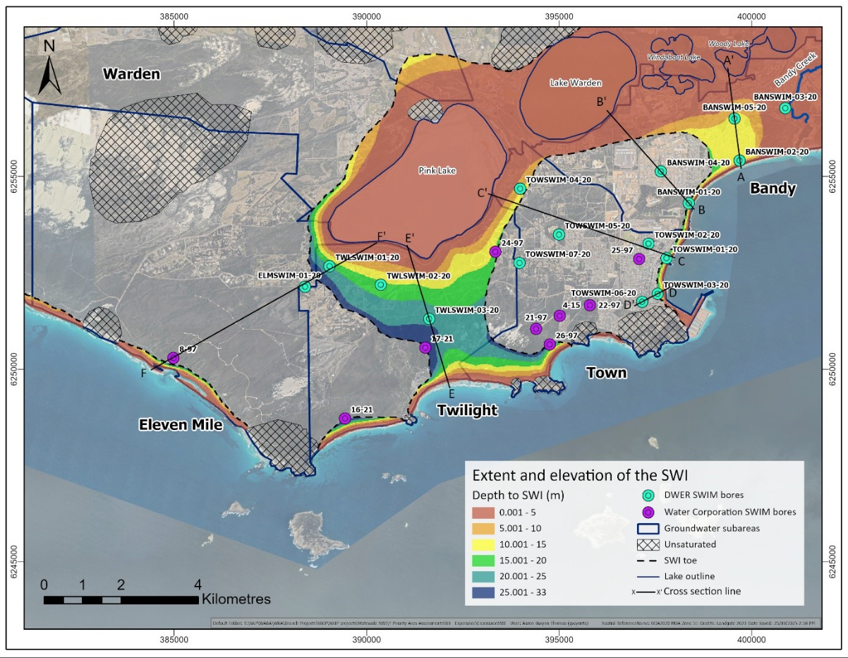
We developed a spatial layer to show the location and depth below water of the saltwater interface (SWI) in the Superficial aquifer (Figure 1). The seawater interface follows the coastline and extends up to 300 metres inland, whereas the saltwater interface extends between 300 to 800 metres parallel to the east and west from the lake edges of Pink Lake and the south of Lake Warden. These differing saltwater sources merge in the Twilight and Bandy subareas. Comparing the extent of the current interface with the map presented in the Esperance groundwater allocation plan: Evaluation statement 2012 – 2020, the SWI has progressed further inland in the north and southwest corners of the Town subarea. The SWI is also observed in the Twilight subarea, moving inland from the coast in the southeast, and from Pink Lake in the northeast.
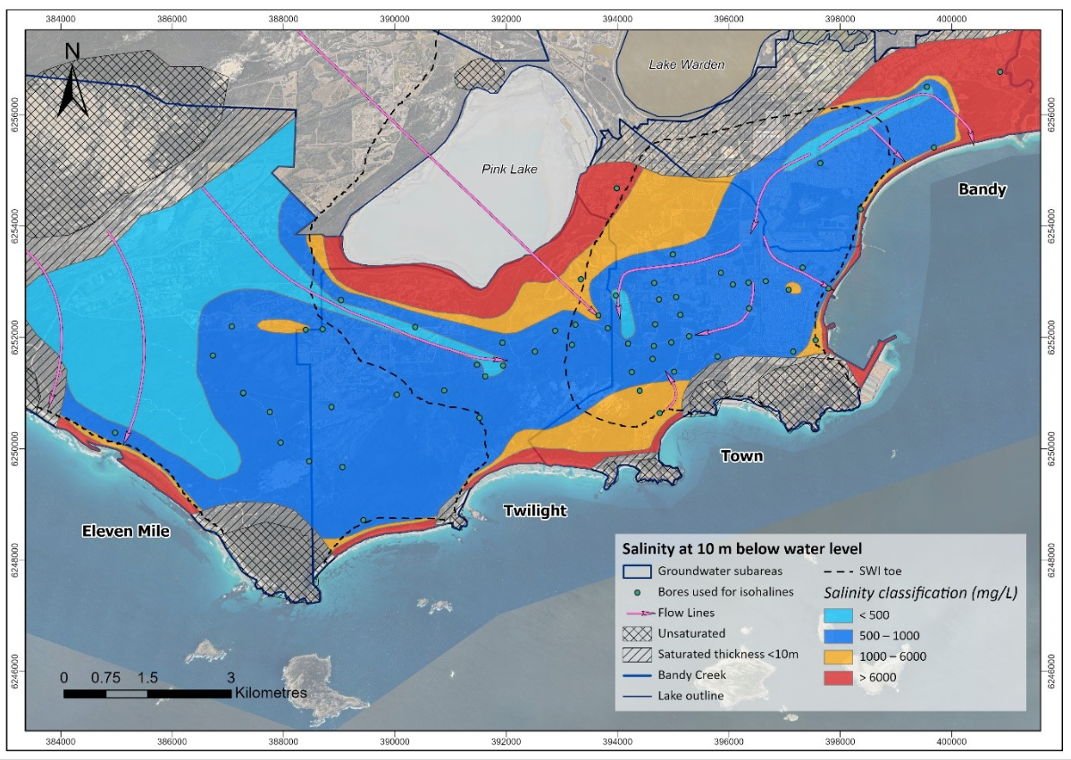
Mixing of saline and fresh water can impact water quality outside of the SWI boundary. To help with identifying where freshwater may be located, we developed a map to show the salinity of groundwater 10 metres below the water table (Figure 2).
We have developed cross-sections which show how salinity moves in each subarea. The cross-sections can be downloaded in the subarea fact sheets below and the depth to seawater interface spatial layer can be downloaded at www.data.wa.gov.au.
Where to get more details
The location and depth of the seawater interface and the distribution of salinity in the Superficial aquifer maps for the Esperance groundwater area are available as spatial layers and can be downloaded via DataWA.
Download the representative cross-section and a brief summary for each subarea below:
Request copies of the internal technical reports for this investigation by emailing groundwater.info@dwer.wa.gov.au.
These include:
- Esperance saltwater interface assessment, Hydrogeological report series, report no. HR437 (Department of Water and Environmental Regulation 2025)
Go to our Water Information Reporting portal to access data from the monitoring bores installed during the investigation.
