Plan release information
The Peel Coastal groundwater allocation plan was released in October 2015.
Supporting documents for the plan were also released:
- Peel Coastal groundwater allocation plan: Methods report
- Peel Coastal groundwater allocation plan: Groundwater-dependent ecosystems
- Peel Coastal groundwater allocation plan: Statement of response.
The statement of response summarises our response to public submissions received on the Peel Coastal groundwater allocation plan: for public comment, released in 2014.
The plan sets out how we will regulate and manage groundwater resources in and around Mandurah. Groundwater is now fully allocated and the plan signals that future water needs will need to be met through improving water use efficiency, water trades and transfers and alternative water sources where appropriate.
Water allocation planning in the Peel Coastal area
The Kwinana–Peel region has one of the fastest rates of population growth across the state. It also has significant environmental features, including the Peel–Harvey estuarine system and the Ramsar-listed Peel–Yalgorup wetlands that are internationally recognised. This means that careful planning is required to manage groundwater use in the area.
This allocation plan sets out updated management for groundwater resources, including:
- new allocation limits that incorporate the effects of a drying climate
- updated local polices to protect the resource from the impacts of abstraction (e.g. saline intrusion)
- aligning water planning and land use planning
- encouraging water trading
- outlining alternative water source options
- improved water accounting, particularly domestic water use
- targeted groundwater monitoring for management and evaluation, including water quality
- a framework to regularly evaluate our management and adapt it if needed.
Plan area
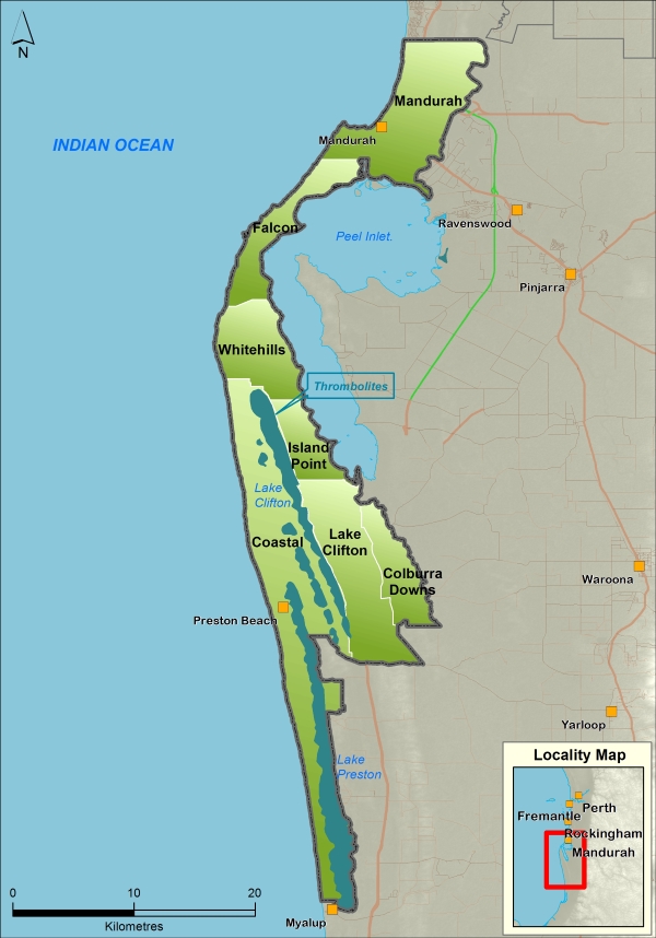
The Peel Coastal groundwater allocation plan covers 380 km2 about 70 km south of Perth. The plan covers the coastal area from the City of Mandurah to Lake Preston, just north of Myalup.
The plan covers part of the South West Coastal Groundwater Area, most of which is in the local government areas of the City of Mandurah and Shire of Waroona.
Water resources
Groundwater in this area is mainly used to irrigate public open spaces, school grounds and domestic gardens, as well as for agriculture and commercial uses. Water is abstracted from the Superficial and Leederville aquifers. The Superficial is the watertable aquifer and the Leederville aquifer generally underlies it.
For management purposes, the Peel Coastal plan area is divided into seven subareas – Coastal, Colburra Downs, Falcon, Island Point, Lake Clifton, Mandurah and Whitehills.
Publications
Peel Coastal groundwater allocation plan
Peel Coastal groundwater allocation plan: Statement of response
Peel Coastal groundwater allocation plan: Methods report
Peel Coastal groundwater allocation plan: Groundwater-dependent ecosystems
Peel Coastal groundwater allocation plan: for public comment