Plan release information
The Lower Collie surface water allocation plan was released in August 2015.
Supporting documents for the plan are also available:
- Lower Collie surface water allocation plan: Statement of response
- Lower Collie surface water allocation plan: Methods report
The statement of response summarises our response to comments and questions we received on the Lower Collie surface water allocation plan: draft for public comment, released in 2011.
The plan includes allocation limits, which outline how much water is available in the Lower Collie plan area. It also regulates winter releases from the Wellington Reservoir into the lower Collie River.
The plan describes how we will allocate and manage water resources and monitor, measure and evaluate the objectives of the plan.
Water allocation planning in the Lower Collie
We developed the Lower Collie surface water allocation plan to set allocation limits, establish winter releases to the lower Collie River and to inform future development decisions in the area, including the potential uses of Wellington Reservoir as a strategic resource for agriculture and industry. The plan outlines allocation limits and rules that guide how water is stored, taken or released.
The Lower Collie surface water allocation plan contributes to the following outcomes:
- Reliable water supplies for self-supply users in a drying climate.
- Sufficient river flows that maintain social and cultural amenity and ecological values in the context of a drying climate and increasing water demand.
- Optimised sharing of water from Wellington Reservoir in drier years.
- Continued and effective scouring of saline water from Wellington Reservoir.
- Transparency for stakeholders about how allocation decisions are made.
The plan contains:
- the total amount of water that is available to be licensed
- water resource objectives and desired plan outcomes
- allocation limits, which are the annual volumes of water set aside for use from each water resource
- release rules for the Wellington Reservoir, based annually on dam storage levels
- local licensing policies to guide how river water is taken, stored and released in self-supply areas
- environmental water provisions, to ensure sustainable management of the river’s ecology
- the 2015 allocation limits and polices replace those set in the 2011 plan for comment.
Plan area
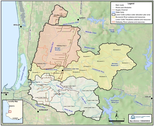
The Lower Collie surface water plan area covers more than 800 km2 in the south-west of Western Australia, about 200 kilometres south of Perth.
The plan area covers the lower Collie River catchment from the base of the Wellington Reservoir as well as the Brunswick and Wellesley rivers and their tributaries. This plan area abuts the Upper Collie surface water plan area.
Water resources
For management purposes the plan area is divided into 24 surface water resources, which are identified on the map below.
For allocation planning and licensing the department refers to these surface water resources instead of the major river or stream that drains the resource unit. As well as the main Brunswick, Wellesley and lower Collie rivers, the plan area includes the Augustus and Lunenburg rivers and numerous small tributaries such as the Henty and Flaherty brooks, and Millers Creek. These watercourses flow into the lower Collie River and into the Leschenault Estuary.
Publications
Lower Collie surface water allocation plan
Lower Collie surface water allocation plan: Statement of response
Lower Collie surface water allocation plan: Methods report
Lower Collie surface water allocation plan: draft for public comment
Environmental flow regime for the lower Collie River: Shentons Elbow reach
Environmental flow regime for the lower Collie River: Wellington reach
Wellington Reservoir water balance simulations: a summary of the TwoRes model scenarios
Surface water hydrology of the lower Collie catchment
Lower Collie River social values study
Brunswick River: surface water management: issue scoping report
Nyungar values of the Collie River
Water-balance modelling of the Leschenault Catchment
Ecological water requirements of the Brunswick River