The Gnangara groundwater allocation plan was released in June 2022.
Supporting documents for the plan are also available:
- Gnangara groundwater allocation plan: Methods
- Gnangara groundwater allocation plan: Statement of response
The statement of response summarises our response to public comments and submissions received on the Gnangara groundwater allocation plan: draft for public comment released in November 2021.
We released the Gnangara groundwater allocation plan – 2024 progress report in December 2024. The progress report provides an update on the implementation of the Gnangara groundwater allocation plan, covering the period from June 2022 to June 2024.
For more information on why the new plan is a necessary response to climate change, how water management is improving and what can be done to secure groundwater for the future visit gnangara.dwer.wa.gov.au.
Water allocation planning for the Gnangara system
Gnangara groundwater – Perth’s largest, most accessible, lowest cost source of fresh water – has become out of balance through less rainfall because of climate change, and continued groundwater use.
The Gnangara groundwater system is a shared resource. Gnangara groundwater supplies almost half of all the water used across Perth. This includes water for Perth’s Integrated Water Supply Scheme and water taken by farmers, local governments, schools, industry, and households from their own bores.
It also supports nationally significant groundwater-dependent ecosystems, such as wetlands and Banksia woodlands. These groundwater-dependent ecosystems support biodiversity, help create our 'sense of place' and make our city an attractive place to live.
The 2009 Gnangara groundwater areas allocation plan provided initial strategies to manage sustainable groundwater abstraction and first steps to returning the over-allocated system to balance, after 40 years of declining rainfall and recharge to groundwater. It was a strong first step in adjusting our groundwater management in the context of drier climate.
The Department of Water and Environmental Regulation developed the 2022 Gnangara groundwater allocation plan to make sure we have a productive and sustainable groundwater supply and healthy environment under a drying climate.
To develop the Gnangara groundwater allocation plan, we consulted with water users to find ways to adjust and to bring our Gnangara groundwater system back into balance by 2032.
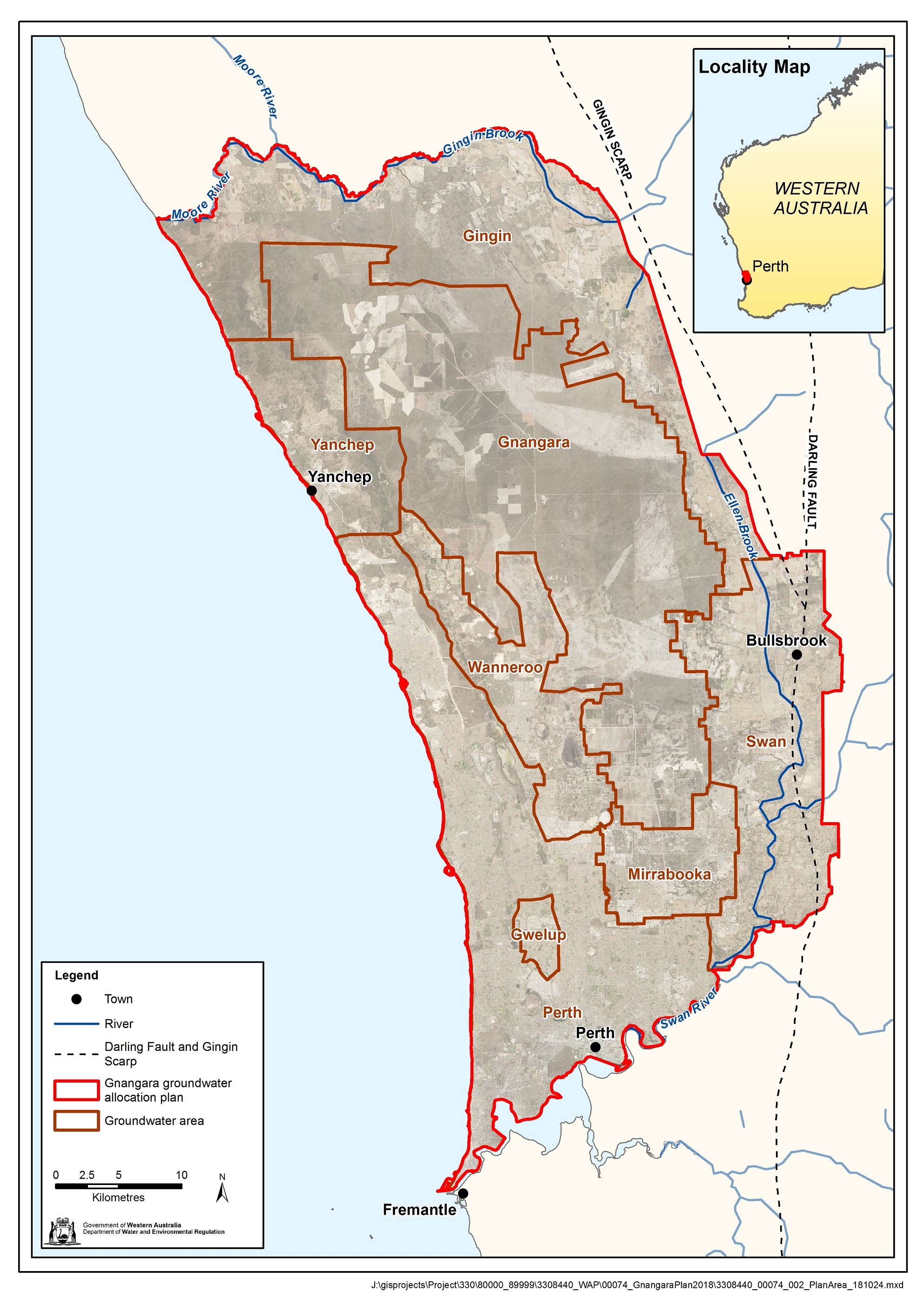
Plan area
The Gnangara groundwater areas cover about 2,200 km2 in the northern part of Perth.
The area covers the groundwater resources of the Yanchep, Gnangara, Wanneroo, Swan, Mirrabooka, Gwelup and Perth groundwater areas and includes a portion of the Gingin groundwater area.
For details on groundwater subareas see Chapter 1 of the plan.
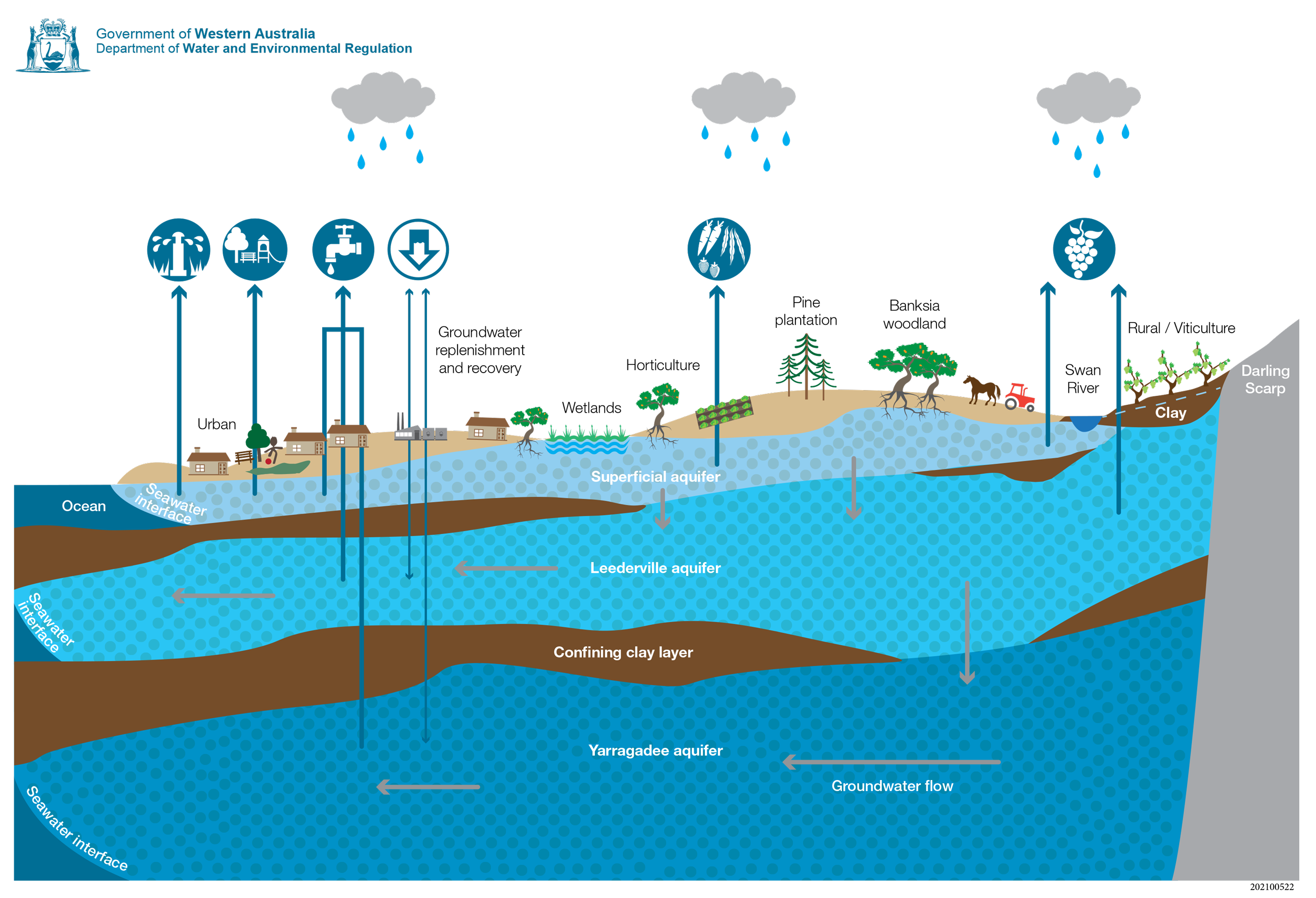
Groundwater resources
The Gnangara groundwater areas consist of three main aquifers:
- the unconfined Superficial aquifer (commonly known as the Gnangara Mound)
- the deep, partly confined Leederville aquifer
- the deep, mostly confined Yarragadee aquifer.
Minor aquifers include the Mirrabooka, Coastal Saline and Fractured Rock aquifers.
Publications
Gnangara groundwater allocation plan – 2024 progress report
Gnangara groundwater allocation plan
Gnangara groundwater allocation plan: Methods
Gnangara groundwater allocation plan: Statement of response
Gnangara groundwater allocation plan: draft for public comment
Gnangara groundwater areas allocation plan 2009
Studying Perth's deep aquifers to improve groundwater management
Connectivity between the north Yeal wetlands and Perth's regional groundwater
Lake Nowergup - Factors in declining lake and groundwater levels
Loch McNess hydrogeology and causes of water-level decline 1975-2011