In the South West region, groundwater supports drinking water, horticulture, pasture production and mining. The environment, recognised for its outstanding biodiversity and importance to the community, is also supported by groundwater. The Yarragadee, Leederville and Superficial aquifers are significant groundwater resources, and water levels in some areas are decreasing due to reduced rainfall and abstraction.
We investigated three high-priority areas in 2009 to improve our understanding of these resources:
- The Bunbury groundwater area (prompted by observations of increased salinity in the Yarragadee aquifer, which is the source of public water supply for Bunbury).
- The Busselton-Capel groundwater area (which has high levels of groundwater use for public water supply and irrigation).
- The Blackwood groundwater area (to investigate the potential of the Leederville and Lesueur Sandstone aquifers as regional groundwater resources).
The State Groundwater Investigation Program and the Australian Government’s Water Smart Australia program jointly funded these investigations.
What we did during the investigation
Through the South West regional reconnaissance investigation we:
- installed one seawater interface monitoring bore at a near-coastal site in Bunbury (GSW1)
- installed four groundwater monitoring bores into the Yarragadee aquifer in the Busselton-Capel area
- installed five groundwater monitoring bores into the Leederville and Lesueur aquifers at two different sites in the Blackwood area
- conducted geophysical logging in the deepest bores to help characterise aquifers
- analysed samples for palynology to estimate geological age and improve our understanding of the stratigraphic relationships
- installed groundwater dataloggers with six-hourly measurements to improve groundwater model calibration, resolve recharge responses, and understand aquifer connectivity.
Key findings and how we are using the information
In the Bunbury groundwater area, we made several key findings:
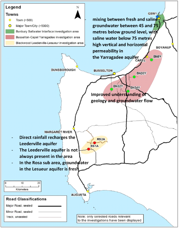
- There is a mixing zone between fresh and saline groundwater between 45 and 75 metres below ground level, with saline water below 75 metres.
- There is high vertical and horizontal permeability in the Yarragadee aquifer at the location of the monitoring bore.
- Induction logging is a relatively simple and repeatable method of identifying the location of the seawater interface.
Installation of groundwater monitoring bores into the Yarragadee aquifer in the Busselton-Capel groundwater area improved the groundwater monitoring network and better defined the area’s geology and hydrogeology.
The investigation of the Leederville and Lesueur aquifers in the Blackwood groundwater area found that:
- direct rainfall recharges the Leederville aquifer
- the Leederville aquifer is not always present
- the Lesueur aquifer has freshwater in the Rosa subarea.
We used our new understanding of aquifer parameters to improve our South West Aquifer Modelling System (SWAMS). Predictions from SWAMS helped revise the allocation limits for the South West groundwater areas allocation plan 2009. We will continue to monitor groundwater levels in these bores to evaluate the resources covered by the plan.
We used the investigation results to guide and optimise targeted investigations, including the South West groundwater areas, Royalties for Regions South West, and Statewide SWI investigations in the Bunbury and Busselton-Dunsborough areas.
Where to get more details
You can download the South West groundwater areas allocation plan 2009.
You can ask for copies of the internal technical reports for this investigation by emailing groundwater.info@dwer.wa.gov.au. These include:
- Bore completion report for the South West regional reconnaissance investigations, HR287 (Denby 2009)
- Hydrogeology related to the South West regional reconnaissance investigations, HR301 (Denby 2011).
Go to our Water Information Reporting portal to access data from the monitoring bores installed during this investigation.
Read more about our groundwater investigations by region across Western Australia.