The Albany groundwater area was proclaimed in 1973 under the Rights in Water and Irrigation Act 1914 to regulate how groundwater is taken and to protect the long-term availability of groundwater. The original proclaimed area was extended in 1975 and 1979. Abstracting and using groundwater in this area requires a licence.
In 2017, we completed the Albany conceptual and numerical groundwater modelling project and the Albany hinterland prospective groundwater resources project. These two projects improved our understanding of groundwater resources in the area.
We are using up to date climate information, groundwater modelling, and existing monitoring and metering data to evaluate the resources in the Albany groundwater area. This information is showing that groundwater levels have declined because of less rainfall and abstraction and in most subareas, groundwater abstraction is at its limit.
The plan does not address access to, or use of, drinking water and wastewater supply. This is managed by the Water Corporation.
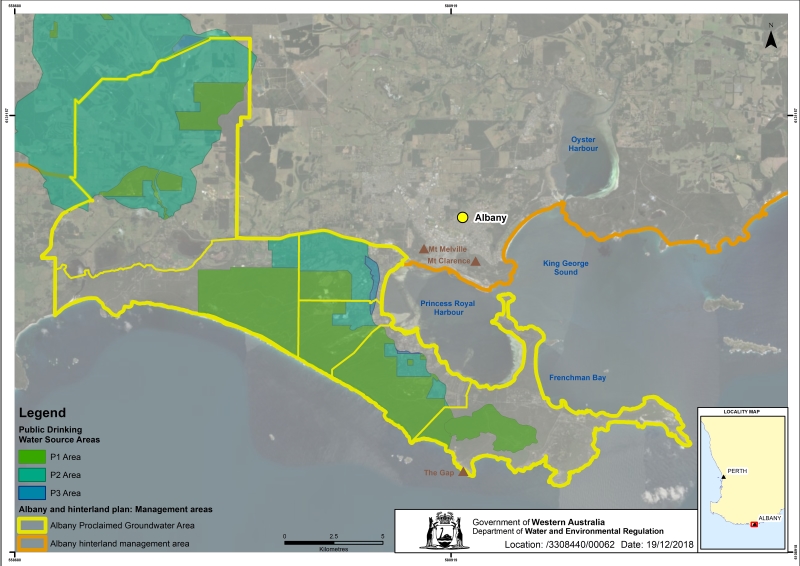
Albany groundwater area
The Albany groundwater area is 410 kilometres south of Perth, on the western margin of the Eucla Basin. It covers about 280 square kilometres and extends eastwards for 34 kilometres from Torbay Inlet, along the Southern Ocean coastline to Bald Head at the tip of Flinders Peninsula.
The Albany groundwater area was proclaimed in 1973 under the Rights in Water and Irrigation Act 1914 to regulate how groundwater is taken and to protect the long-term availability of groundwater. The original proclaimed area was extended in 1975 and 1979. Abstracting and using groundwater in this area requires a licence.
The most significant groundwater supplies for the Albany region are in the sedimentary aquifers of the Eucla Basin. The basin is a geological formation extending the length of Western Australia’s southern coastline. The aquifers present in the Albany groundwater area are the Superficial, Middle Sands and Werillup aquifers.
Water for private use, such as horticulture, industry and stock and domestic use, is sourced from the unconfined watertable aquifer (Superficial aquifer). The public drinking water supply is sourced from the confined Middle Sands and Werillup aquifers, and currently makes up over 90 per cent of the public water supply for the Lower Great Southern area.
The coastal strip of the groundwater area is covered by dense native vegetation, located in City of Albany reserves and Torndirrup National Park. The western third extends 14 kilometres inland through agricultural land, overlapping the Marbellup Brook catchment area water reserve.
Water quality in the Albany groundwater area is protected from contamination by managing land uses and associated activities in the South Coast Water Reserve water source protection area. The protection area was proclaimed in 1968, then realigned in 2001 to reflect the capture zones of the supply bores, current land uses, and to allow for future expansion of the borefield.
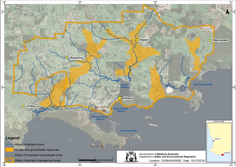
Albany hinterland
The Albany hinterland extends 25 kilometres inland, covering 1,200 square kilometres from the north west to the north east of the Albany urban area. The hinterland takes in the localities of Redmond, Napier and Manypeaks. The hinterland has strong potential for to support expansion in agricultural, fit for purpose industrial or potable (drinking water) supplies.
The unproclaimed Albany hinterland contains several large areas of groundwater. In unproclaimed areas, access to confined (or artesian) groundwater, is regulated under the Rights in Water and Irrigation Act 1914. Non-artesian groundwater in unproclaimed areas is unregulated at this stage.
The four hinterland areas with prospective groundwater resources were identified through the government funded South Coast groundwater investigation project. The study revealed a better picture of the groundwater resources in the Albany hinterland area.
You can find information on likely water availability, quality, quantity, location and extent of each resource on the detailed Albany hinterland prospective groundwater resources map.
Publications
Great Southern regional water supply strategy
Marbellup Brook catchment area drinking water source protection plan
South Coast Water Reserve and Limeburners Creek Catchment area water source protection plan
Albany hinterland prospective groundwater resources map
Albany hinterland prospective groundwater resources map - explanatory notes
Mapping water availability in the palaeochannels of the Albany hinterland