What is the WAVE Pilot?
WAVE stands for WA Vegetation Extent. It’s a pilot study by the Department of Water and Environmental Regulation designed to investigate the potential of machine learning to map our native vegetation.
The study involves trialling a range of approaches to see if we can improve the way we gather data on WA’s native vegetation across the vastness of Western Australia.
In simple terms...
...we’re training machine-learning systems to recognise native plants from satellite imagery. The challenge is for these technologies to accurately identify native plants across a variety of landscapes.
Ultimately, the process is helping us decide whether AI technologies are ready to play a part in the important work of mapping our native vegetation – and to what degree.
There’s no wrong answer
Regardless of the outcome, the WAVE Pilot project is important for two reasons: Firstly, it’s already advancing our capabilities in data and emerging technologies and, secondly, it’s part of our essential efforts to ensure WA’s diverse vegetation is accurately accounted for in policies and decisions.
Why is WAVE so important?
Every day, government planners, industry project managers, Traditional Owners and conservation bodies make decisions about native vegetation.
The issue we face is that WA is vast. It’s hard to get comprehensive data on the extent of native vegetation in any given area, at any given time. This means decisions sometimes need to be made without adequate data. WAVE is a step towards more definitive data and better-informed decisions, accessible to everyone.
Scale demands innovation
Our state’s incredible 2.5 million square kilometre landmass makes manual vegetation mapping impractical, especially as our maps need to be updated regularly to capture changes.
But now, for the first time, this pilot is testing whether machine learning has reached the level of sophistication required to build accurate, automated vegetation detection tools.
Potentially, the pilot will lead to a new, comprehensive source of data for the many organisations that need to account for native vegetation when making decisions.
The outcome of the pilot is by no means guaranteed but what we do know is that the process itself is already moving our understanding forward and bringing us closer to a better way of mapping.
How it works
We’re testing AI-driven image and pattern recognition technology that can identify vegetation and changes in satellite imagery.
Although the pilot is currently confined to three test areas, the hope is that the technology can be scaled up to map native vegetation across millions of square kilometres, identifying clusters of native vegetation.
Our landscapes are nearly as diverse as our plant life, so we’re testing and developing multiple data sources and processing methods across different landscape conditions to see what works and what doesn’t.
Machine learning technology is not here to replace human decision making. It’s a tool to help us recognise and classify patterns in vast amounts of information, much of which is not visible to the human eye. The vegetation analysis outcomes provided by the tools will always be subject to human scrutiny.
And, once the data has been considered, the responsibility for making decisions is firmly back in human hands.
What will WAVE mean for you?
Depending on the findings of the pilot, potential benefits for different groups include:
Government and policy
- Better planning data: Timely evidence-based decisions with comprehensive vegetation information
- State capability: Building WA’s innovation and data infrastructure
- Risk reduction: More consistent, dependable data reduces uncertainty in policy decisions
Industry and development
- Project planning: Better data for development proposals and approvals
- Reduced uncertainty: More comprehensive vegetation information available upfront
- Streamlined processes: Standardised, publicly available data potentially reduces assessment timeframes
Communities and Traditional Owners
- Supporting country care: Technology to support traditional land management
- Collaborative approach: Combining traditional knowledge and on-ground experience with modern detection tools
Conservation and environment
- Protection through knowledge: Better data for more effective conservation decisions
- Change monitoring: Potential to track gains and losses over time
- Evidence-based action: Publicly available data that carries more weight for conservation efforts
Research and technical partners
- Innovation leadership: Advancing WA’s research and technical capabilities
- Knowledge contribution: Contributing to global vegetation mapping science
- Technical excellence: Rigorous scientific approach to capability building
The latest...
The technical development phase is now complete! The WAVE Pilot has demonstrated that deep learning models applied to satellite imagery, combined with a focus on training data development, can effectively map native vegetation in Pilot areas in WA.
Next steps
A potential modelling approach has been developed to progressively scale up and out from computer models to statewide, regularly updated vegetation data products that can be used for monitoring. The focus of the pilot project is now on finalising testing, refining results and then evaluation of the method on its merits for further scale-up.
Stay informed
Sign up to stay informed and we’ll email you with progress reports as information becomes available.
Contact information
For general enquiries, technical questions or stakeholder liaison, please email WAVEpilot@dwer.wa.gov.au.
Frequently asked questions
Understanding WAVE Pilot
Show more1. What is the WAVE Pilot project?
WAVE (WA Vegetation Extent) Pilot is testing whether machine learning (AI) can help map and monitor Western Australia’s (WA’s) native vegetation more extensively and accurately. The goal is to see if this technology can give us better, more consistent information to support land use, conservation and planning decisions across the Western Australia (WA).
2. Why does WA need WAVE Pilot?
WA is large, with a wide variety of unique vegetation. WAVE Pilot is testing whether new technology can give us a more reliable, up-to-date snapshot of where vegetation exists and how it’s changing, so everyone, from government planners to communities, can make more informed decisions.
3. What does ‘vegetation extent’ mean?
Extent simply means how much land is covered by vegetation at a certain time. That includes forests, grasslands, shrubs and even sparse or seasonal vegetation that only appears after rain.
About the pilot
Show more4. What stage is WAVE Pilot at now?
WAVE Pilot is trying out different AI and mapping methods to see what works best across WA’s landscapes. The team is still testing and learning, and results will be shared once evaluation is complete.
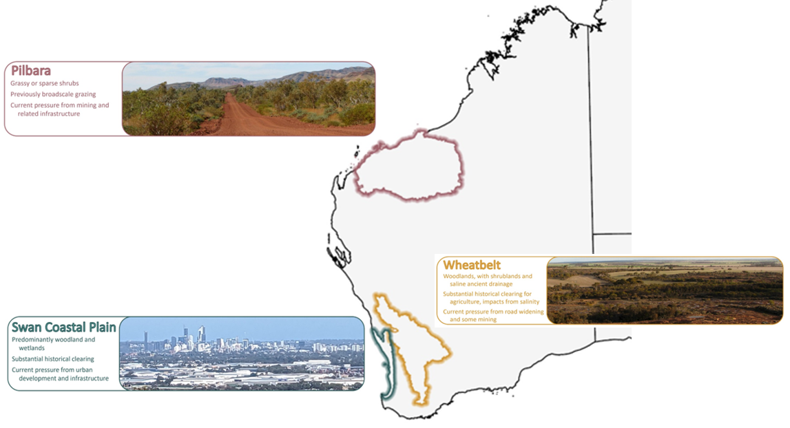
5. What are the pilot areas and why were they chosen?
The pilot project focuses on three high-priority areas: the Swan Coastal Plain, Avon Wheatbelt and Pilbara bioregions. These areas were chosen for their varied landscapes and vegetation.
6. When will we have a result?
The pilot proof of concept system is still being developed. A way forward for WAVE to proceed to state-wide implementation will be proposed to the Government of Western Australia for consideration in 2026. Development of a roll out across the state would likely take a few years. Interim updates to existing vegetation maps are available now for Perth and Peel, with Wheatbelt mapping underway for delivery in mid-2026.
7. What happens if the technology isn’t ready for full use?
Even if full automation isn’t possible, the pilot will still give us valuable insights. It will help us understand current limitations, build WA’s technical capability and guide how we improve vegetation mapping in the future.
8. Does this mean WAVE Pilot will definitely be developed into a state-wide system?
No. The pilot is testing feasibility. If it’s successful, a business case will be developed for State Government consideration on whether to support any state-wide rollout.
Collaboration and impact
Show more9. Who is involved in the pilot?
The pilot is led by the Department of Water and Environmental Regulation (DWER), working with seven other WA government bodies: Department of Planning, Lands and Heritage; Department of Biodiversity, Conservation and Attractions; Department of Primary Industry and Regional Development; Department of Mines, Petroleum and Exploration; Department of Fire and Emergency Services; Landgate and the Environmental Protection Authority. The pilot is also engaged with a variety of scientific, academic and industry research partners, and technical experts.
10. Who benefits from WAVE Pilot?
Governments, land managers, Traditional Owners, industry, conservation groups and researchers will all benefit from having access to more reliable vegetation data.
11. How will WAVE Pilot improve decision-making?
If successful, WAVE Pilot will provide a process for developing consistent, evidence-based data to help decision makers make clearer, more confident choices about land use, conservation and planning.
12. Will WAVE Pilot replace human judgment?
No. WAVE Pilot is developing a tool to help experts analyse large amounts of data. Humans will interpret the results and make the final decisions.
13. How does WAVE Pilot create value even during testing?
Every stage of the pilot teaches us something new. It tests different approaches, strengthens collaboration and improves future mapping, even if full automation isn’t reached.
14. Could other states use this approach?
Possibly. If WAVE Pilot is successful, the approach could help shape national standards and support similar programs elsewhere.
Practical information
Show more15. While WAVE Pilot is being developed, what information is being used to make decisions?
Decision makers are using the best available information. To fill gaps, the government has created interim mapping products for high-priority areas like the Swan Coastal Plain, the metropolitan and Peel regions, and the Wheatbelt.
16. Can I get involved?
Yes, if you have ground-truthed vegetation data from pilot regions (especially from 2015 onwards), the team would love to hear from you. Please contact WAVEpilot@dwer.wa.gov.au.
17. How does WAVE Pilot use AI?
AI is being tested to see if it can identify native vegetation from satellite imagery. It looks for patterns, colours and textures, including some that are beyond the range visible to human eyes, in huge datasets to detect changes that can be hard to spot manually. Experts review outputs to make sure they are accurate.
Addressing common concerns
Show more18. Is AI replacing jobs?
No, there aren’t any ongoing roles doing this work. The information that AI can use goes beyond the capability of human eyes to perceive and it can process vast quantities of data unrealistic for humans to do. If the project is successful, it could create new opportunities, including roles that supervise the AI outputs, coordinate the delivery of the data, and involve engaging remote and Indigenous communities in ground-truthing and validating the data.
19. Is my backyard being watched or monitored?
Not by WAVE Pilot! WAVE Pilot looks at broad vegetation patterns, not individual properties. It’s about environmental trends, not people.
20. Will WAVE Pilot change how projects are assessed?
No. WAVE Pilot is working to provide better data for existing processes. It won’t replace assessments but will give decision-makers more confidence.
21. I still don’t fully understand the WAVE Pilot.
That’s OK. You can contact the WAVE team at WAVEpilot@dwer.wa.gov.au and we’ll help answer your questions.