Plan release information
The Department released the Consultation draft – Fitzroy–Derby water resources management plan: policy and guidance on 1 April 2026. The draft plan is supported by the Consultation draft – Fitzroy–Derby water resources management plan: methods.
Public consultation and submissions closed at 5pm, 30 June 2026. We are now reviewing submissions and feedback received on the draft plan during consultation. This will inform the final Fitzroy–Derby water resources management plan: policy and guidance.
Please read below to learn about the draft plan or see our frequently asked questions page.
Fitzroy-Derby water planning
Show moreThe draft Fitzroy-Derby plan combines water planning for the Fitzroy River catchment and the Derby Peninsula. It is the first water plan for the Fitzroy River catchment and related groundwater resources in the Canning–Kimberley groundwater area. It replaces previous water plans for the Derby groundwater area.
The State Government is committed to protecting the Fitzroy River while supporting opportunities for sustainable economic development. The State Government's Water allocation planning in the Fitzroy – Policy position paper (2023) outlines the key policy positions that the draft Fitzroy–Derby plan is based on.
The policy positions were developed following extensive consultation on the Managing water in the Fitzroy River Catchment – Discussion paper for stakeholder consultation (November 2020) (view the Summary of submissions and more information) and were also informed by scientific studies (view the Fitzroy technical reports page).
The draft plan was also informed by the valued and thorough feedback received on the Department’s 2020 Derby groundwater allocation plan: for public comment (now replaced by this draft Fitzroy-Derby plan) and the ongoing conversations with Traditional Owners.
The Fitzroy policy positions
Show moreOn 23 October 2023, the state Government released the water allocation planning in the Fitzroy - Policy position paper. The paper outlines the key policy positions that the draft Fitzroy–Derby plan is based on.
- The State Government will not allow the Fitzroy River or its tributaries to be dammed.
- The State Government supports the licensed take of groundwater only where it is shown to be sustainable.
- The State government will restrict access to Alluvial and Devonian Reef aquifers.
- The State Government confirms that no additional surface water will be licensed.
- The State Government will establish a Fitzroy Aboriginal Water Reserve.
- The State Government supports a process that enables Traditional Owners to exercise their water-related cultural heritage and Native Title rights and provide advice to water planning and licensing.
- The State Government expects developments to avoid or minimise impacts on ecological, cultural and social values.
- The State Government supports aligning water licensing requirements with other regulatory decisions in a transparent way.
- The State Government supports a considered approach to water developments.
- The State Government remains committed to establishing an advisory group.
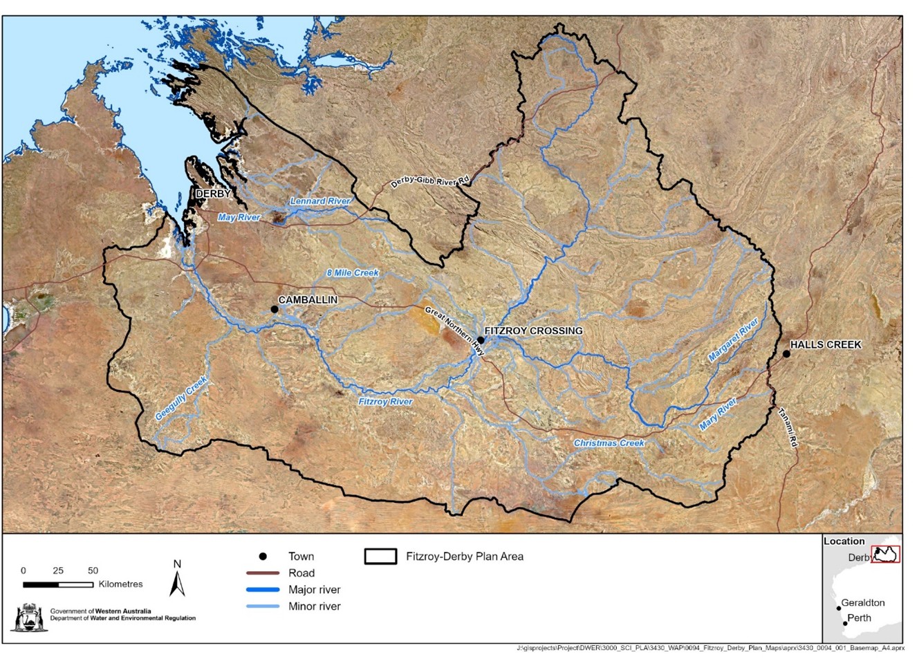
Fitzroy-Derby plan area
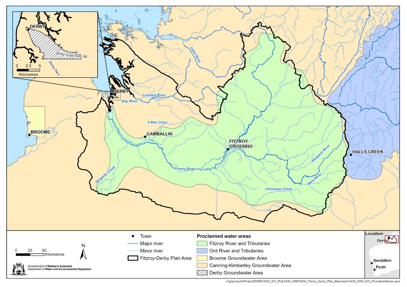
Show moreThe draft plan covers the Fitzroy River Catchment and groundwater resources which underlie the river, the Derby Peninsula, and extend to the north.
This area was proclaimed for both groundwater and surface water under water legislation, as the Derby groundwater area (1968), part of the Canning–Kimberley groundwater area (1997) and the Fitzroy River and Tributaries surface water area (1959). This means people who want to use water from the rivers and aquifers in these areas require a water licence to lawfully take surface water or groundwater. A water licence is not needed to take water for small-scale stock and domestic needs.
See our regulatory documents for more information on water licensing and exemptions.
Water resources
Show moreThe Fitzroy-Derby plan area covers:
- Surface water in the proclaimed portions of six water resources covering the Fitzroy River catchment
- Groundwater aquifers in the Derby and Canning-Kimberley groundwater areas, including the following aquifers:
- Canning–Alluvial
- Canning–Broome
- Canning–Wallal
- Canning–Erskine
- Canning–Liveringa
- Canning–Noonkanbah
- Canning–Grant-Poole
- Canning–Devonian Reef
- Fractured Rock
Previous water plans and consultations
Show moreSee our Fitzroy-Derby plan consultation page to find out about consultation and submissions on the draft Fitzroy-Derby plan.
Previous water plans in the Fitzroy-Derby plan area were the:
- superseded Derby groundwater allocation plan: for public comment 2020 (replaced by Consultation draft – Fitzroy–Derby water resources management plan: policy and guidance)
- superseded Derby groundwater management plan 1992.
Summaries of our previous consultations and the submissions we received:
- Consultation summary – Fitzroy-Derby water planning
- Summary of submissions – Derby groundwater allocation plan: For public comment
- Summary of submissions – Managing Water in the Fitzroy River Catchment: Discussion paper for stakeholder consultation (2020)
We will also publish a summary of submissions alongside the final Fitzroy–Derby water resources management plan: policy and guidance.
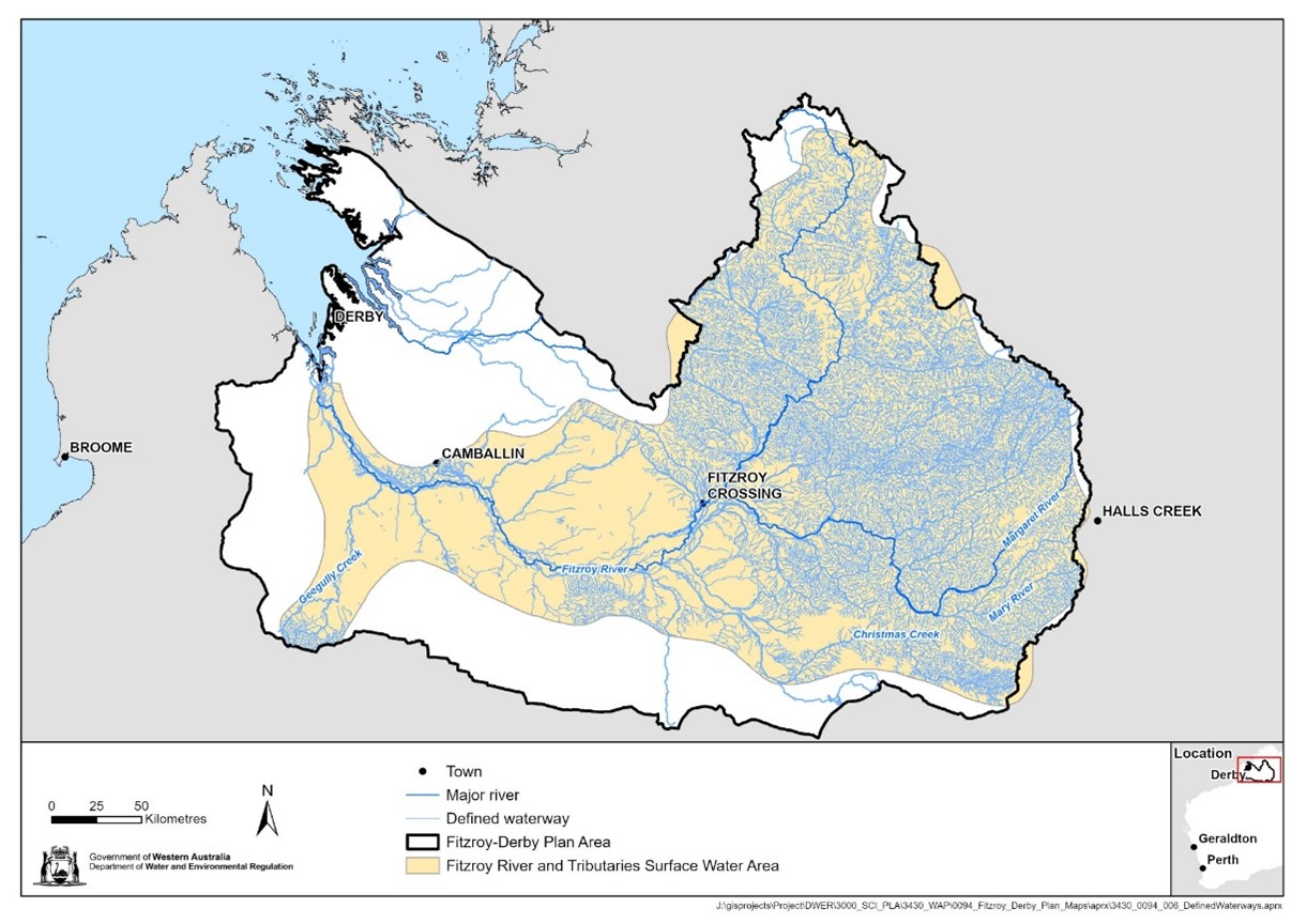
Defined waterways map
Show moreThe Consultation draft – Fitzroy–Derby water resources management plan: policy and guidance establishes defined waterways where the ‘no dams’ policy applies. Defined waterways in the proclaimed Fitzroy River and Tributaries surface water area are depicted in the defined waterways map.
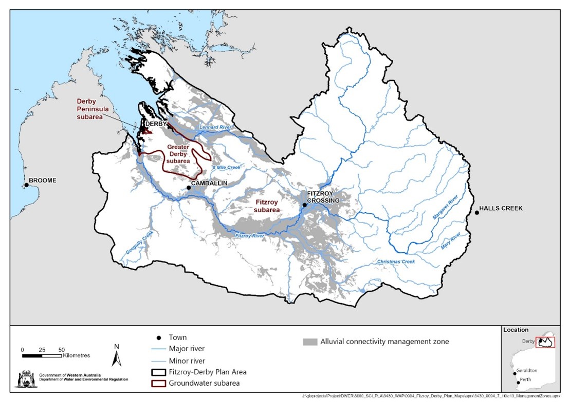
Water management zone maps
Show moreThe Consultation draft – Fitzroy–Derby water resources management plan: policy and guidance established four water management zones where specific, additional local licensing policies apply:
- Alluvial connectivity management zone – relates to the Alluvial aquifer and aquifers underlying it
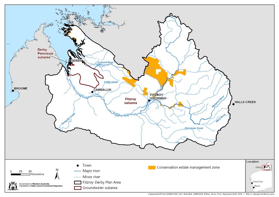
- Conservation estate management zone – relates to protecting environmental values, including cultural and heritage values, in national and conservation parks
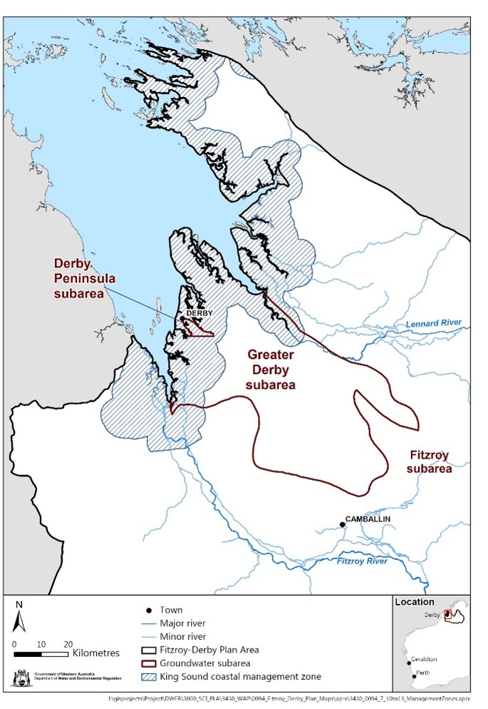
- King Sound coastal management zone – relates to managing the saltwater interface in aquifers along the coast
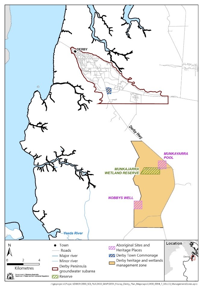
- Derby heritage and wetlands management zone – relates to protecting the Derby Town Commonage heritage place and Munkajarra wetlands.
Download these maps below.
Alluvial connectivity management zone map
Conservation estate management zone map
King Sound coastal management zone map
The Derby heritage and wetlands management zone map
Shapefiles can be requested by emailing fitzroyderbywaterplanning@dwer.wa.gov.au.
Technical reports published for Fitzroy water planning
Show moreIn 2023, we published five technical reports for Fitzroy water planning.
View this detailed information and download the reports and maps on our Fitzroy technical reports page.