Plan release information
The La Grange groundwater allocation plan and Statement of response were released in February 2010.
The statement of response summarises our response to public comments and submissions received on the draft plan released for public comment.
The plan includes allocation limits, which define how much water is available in the La Grange area. It describes how we will allocate and manage water resources and how we monitor, measure and evaluate the objectives of the plan.
The plan was amended through the La Grange groundwater allocation statement in September 2025. The statement updates local licensing policies, communicates recent findings from the La Grange groundwater-dependent ecosystems investigation, and provides guidance to proponents.
We periodically release updates on progress in meeting plan objectives. The evaluation statements are available below:
- La Grange groundwater allocation plan: Evaluation statement 2012–2017
- La Grange groundwater allocation plan: Evaluation statement 2011–2012
- La Grange groundwater allocation plan: Evaluation statement 2010–2011
Water allocation planning in the La Grange area
There is a great deal of interest in using the La Grange groundwater in horticulture and mining development. That's why planning is essential, so that the needs of the community and the environment are protected and water supplies remain secure.
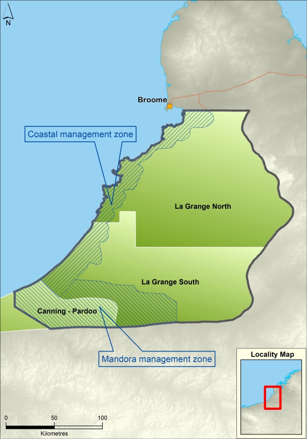
Plan area
The La Grange plan area is just south of Broome and about 1,440 kilometres north of Perth. The La Grange plan area contains culturally and ecologically significant sites that depend on groundwater, including springs within the Walyarta Conservation Park, the Eighty Mile Beach wetland system and the Roebuck Bay wetland system. The Coastal and Mandora management zones have been established to manage these sites.
The plan is within the Canning-Kimberley groundwater area.
Water resources
The Broome Sandstone aquifer extends across the plan area and is underlain by the deeper Wallal Sandstone aquifer.
For management purposes, the plan is divided into two subareas – La Grange North and La Grange South.
Publications
La Grange groundwater allocation plan
La Grange groundwater allocation plan: Statement of response
La Grange groundwater allocation statement
La Grange groundwater allocation plan: Evaluation statement 2012–2017
La Grange groundwater allocation plan: Evaluation statement 2011–2012
La Grange groundwater allocation plan: Evaluation statement 2010–2011
La Grange groundwater allocation: a Kimberley sub-regional allocation plan
Wetlands of the northwestern Great Sandy Desert in the La Grange hydrological sub-basin