A foreshore area (or foreshore reserve) is the land that adjoins or directly influences a waterway.
It is the area of transition between the edge of the waterway and the furthest extent of riparian vegetation, the floodplain and riverine landforms. Or it is a negotiated area endorsed by the Department of Water and Environmental Regulation (and the Department of Biodiversity Conservation and Attractions within or abutting the Swan Canning Riverpark and Development Control Area).
A foreshore area is part of the waterway’s ecosystem and performs many important environmental functions, so their protection, restoration and good management is critical for healthy waterways. Well-planned and managed foreshore reserves allow people to access and enjoy our waterways.
Unfortunately, many historical and current land use practices and activities have caused widespread waterway degradation, particularly in south-west Western Australia. This is reflected in the poor condition of many waterway foreshores.
Foreshore condition assessments
Foreshore condition assessments provide information on the state or condition of the foreshore area of a waterway at a given time.
They enable local communities, supported by government agencies and other professionals, to make the most effective use of resources for river protection.
These assessments can inform waterway restoration planning. For example, the most urgent management issues can be targeted for immediate rehabilitation; or areas in the best condition can be protected from any development occurring nearby. It is not always effective to prioritise the most degraded areas of the foreshore area first.
Volunteers can be trained to recognise degrees of foreshore degradation and record their assessment of foreshore condition on standardised forms, which ensure consistency in the method used. The resulting data can be gathered together to produce a record of foreshore condition over large areas. This provides baseline data on which to base long term monitoring and management.
Pen and Scott (1995) developed a foreshore condition assessment system for farming areas in south-west Australia. The foreshore condition assessment system considers elements such as vegetation health, presence of weeds, livestock access and fencing status, bank steepness and potential for erosion. Foreshores are given a grade reflecting the level of degradation found (see Figure 1 below). Later this second method was developed for assessing foreshore condition in urban and semi-rural areas.
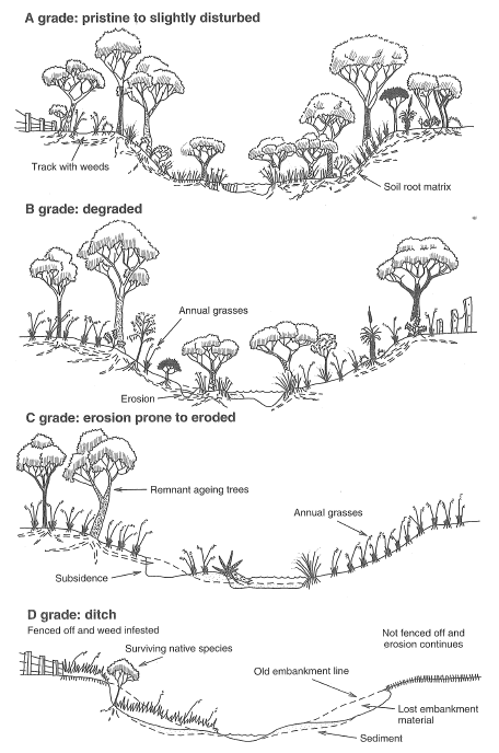
Figure 1. The four grades of river foreshore condition following the general process of river degradation from pristine (A) to ditch (D) (Source: River Restoration Manual Report No. RR3).
The assessment methods are summarised in the following reports of the River Restoration Manual:
- Foreshore condition assessment in farming areas of south-west Western Australia (RR3)
- Foreshore condition assessment in urban and semi-rural areas of south-west Western Australia (RR2).
Foreshore conditions spatial dataset
Information from Western Australian foreshore condition assessments is collated in the Foreshore Conditions spatial dataset.
It incorporates data from more than 60 reports for selected waterways from south of Kalbarri to west of Esperance (see Figure 2), that provide a snapshot of the river condition at a point in time. The information was collected by Natural Resource Management groups, such as Geocatch, with support from our regional offices as part of state and federally funded foreshore assessment projects undertaken between 1992 and 2008.
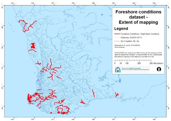
Figure 2. The spatial extent of foreshore condition assessments in the Foreshore Conditions spatial dataset for south-west Western Australia.
The dataset can be downloaded from Landgate via DataWA or viewed using Locate, Landgate’s public map viewer. The dataset covers a number of indicators which are available as nine different layers under the water theme:
- Left bank condition (DWER-009) and right bank condition (DWER-011)
- Assessment of left bank (DWER-005) and right bank protection fencing (DWER-006)
- Fencing linework (DWER-008)
- Weed infestations (DWER-013)
- Erosion (DWER-007)
- River access points (e.g. for livestock, vehicles, boats and pedestrians) (DWER-012)
- Points of interest (DWER-010).
Note that not all projects assessed all indicators. Figure 3 shows a sample of the left bank conditions data from past foreshore conditions assessments undertaken in the Margaret area.
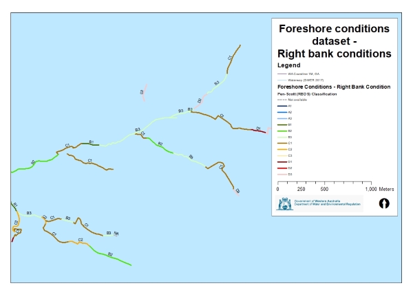
Figure 3. A sample of data from the Foreshore conditions dataset - left bank condition data from past foreshore conditions assessments undertaken in the Margaret area.
The foreshore condition assessment reports can also be downloaded from the Waterways management plan collection.
See also
For information about foreshores within the Swan and Canning catchments, refer to the Department of Biodiversity Conservation and Attractions Swan Canning Riverpark.