Plan release information
The Jurien groundwater allocation plan and Statement of response were released in September 2010.
We reported on the first year of the plan's implementation in the Jurien groundwater allocation plan: Evaluation statement 2010–2011.
In June 2019, we released the Dinner Hill subarea allocation statement which supports the Jurien groundwater allocation plan.
Water allocation planning in the Jurien area
Demand for groundwater from the northern Perth basin is increasing. Commercial growth in the mining industry, new horticultural projects, and expanding urban development along the coast is leading to competition for good quality, fresh water.
Careful planning is needed to provide users with access to reliable water while meeting the needs of the environment in a drying climate.
The Jurien groundwater allocation plan contains:
- allocation limits, which define how much water is available from the Jurien groundwater area
- licensing policies for how groundwater resources will be allocated and managed
- objectives, strategies and performance indicators for monitoring and measuring the effectiveness of the plan
- how we will implement the plan and evaluate information, including implementation actions and the process for reporting on performance.
Dinner Hill is a subarea of the Jurien groundwater area. We reviewed the water supply potential of this subarea as part of the State Government's Midlands Groundwater and Land Assessment project to realise Western Australia's irrigated agriculture potential.
The Dinner Hill subarea allocation statement includes:
- an increased allocation limit for the Leederville–Parmelia aquifer in the Dinner Hill subarea
- more water available in the west and north of the subarea
- licensing objectives and policies specific to the Dinner Hill subarea
- monitoring and future resource investigations.
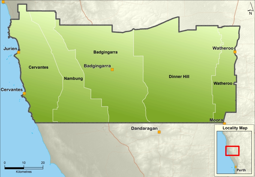
Plan area
The plan covers the Jurien groundwater area, which is 150 kilometres north of Perth and covers about 5,000 km2.
Along with the Gingin and Arrowsmith groundwater areas, Jurien is part of the Northern Perth Basin.
Water resources
The groundwater resources in the plan are the unconfined superficial and surficial aquifers, fractured rocks and the semi-confined to confined aquifers of Mirrabooka, Leederville–Parmelia, Yarragadee, Cattamarra, Eneabba, Lesueur and Otorowiri.
For management purposes, the Jurien groundwater area is divided into five subareas – Badgingarra, Cervantes, Dinner Hill, Nambung and Watheroo.
The department reviewed the water supply potential of the Dinner Hill subarea as part of the Midlands groundwater and land assessment. The assessment was part of the Water for Food program, a state government initiative to realise the state’s irrigated agriculture potential.
Publications
Jurien groundwater allocation plan
Arrowsmith and Jurien groundwater allocation plan: Statement of response
Jurien groundwater allocation plan: Evaluation statement 2010-2011
Dinner Hill subarea allocation statement
Jurien groundwater subarea reference sheets
Environmental considerations for groundwater management in the Northern Perth Basin
Groundwater investigation program in Western Australia (2005 to 2020)
Hydrogeology of the Swan Coastal Plain between Cervantes and Leeman
Hydrogeology of groundwater dependent ecosystems in the Northern Perth Basin