Erosion is the transport by wind, water and ice of soil, sediment and rock fragments produced by the weathering of geological features.
Sedimentation occurs when eroded material that is being transported by water, settles out of the water column onto the surface, as the water flow slows. The sediments that form a waterway's bed, banks and floodplain have been transported from higher in the catchment and deposited there by the flow of water.
Read more about the causes of erosion and what can be done to prevent or reduce erosion in our waterways.
How waterways and estuaries are shaped
Show moreEstuaries are shaped by the mixing of water and sediments from both a waterway and the ocean, which creates complex sedimentary environments.
Waterways, and their estuaries, are dynamic landforms and deposited sediments will be moved again under the right conditions. The channel size, shape and bed material change, both over time and in response to changes in water flow and sediment load.
A channel is considered to be relatively stable when its water flow and sediment flux are in balance over time. If there is a change in either of these factors, then the channel will adjust its slope, depth, width, meander pattern, bed composition and vegetation density accordingly.
Causes of excessive erosion and sedimentation
Show moreLand use and management practices
While erosion and sedimentation are natural processes, poorly planned land use and inappropriate management practices in the catchment can accelerate these processes and stimulate adjustments in the channel.
Read more in our River Restoration Manual: Chapter 18 - Stream channel and floodplain erosion and Chapter 19 - Stream and catchment hydrology (section 7).
Erosion is also caused by activities that directly damage a waterway's channels or banks, including straightening or deepening channels for flood control, building dams, bridges or crossings, allowing uncontrolled livestock access and removing riparian (fringing) vegetation.
Clearing vegetation
Riparian vegetation plays a critical role in stabilising the sediments that form waterways. Living plants slow water flow and reduce its erosive power, while root networks hold the sediments in place.
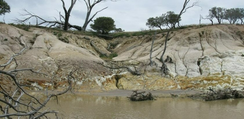
When waterway banks are cleared of their vegetation, they are more vulnerable to erosion. Floods are more likely to cause waterways to change their course and form new meanders or flood channels. Topsoil can also be stripped from the floodplain leading to the loss of valuable agricultural land.
The impact of excess sediments on waterways
Show moreExcess sediment can be damaging to the ecological health of waterways and reduce their environmental, social and cultural values. Mobilised coarse sandy sediment tends to accumulate in areas of slow waterflow and may smother bottom-dwelling organisms and their habitats. Deep permanent river pools, that are valuable habitats for aquatic fauna and refuges for wildlife during summer and drought, may become filled by coarse sediment.
Large sediment accumulations can ruin critical refuge habitat, cause upstream flooding, deflect the flow into the adjacent stream bank or even onto adjacent land, causing further erosion. In addition sediment can fill the deep permanent pools of rivers.
Increased fine sediment suspended in the water column (turbidity) reduces the penetration of light and reduces the ability of algae and other aquatic plants to photosynthesise. It also clogs the gills of fish and smothers benthic habitats and organisms. Fine sediment and the nutrients it transports affect the health of our estuaries and are associated with seasonal blue-green algal blooms. As a consequence of excess sediment, the abundance and distribution of aquatic plants and animals change, natural food webs are disrupted and aquatic diversity declines.
Sediments carry nutrients and contaminants and also accumulate organic matter over time. In estuaries, they can contain a large store of nutrients which influence the ecology (e.g. animals living in the sediments) and the quality of water at the bottom of the estuary. These nutrients may be locked up in the sediments, converted and released as biologically unavailable forms, or recycled back into the water column in a form that supports ongoing plant and algal growth. Excess sediment alters the quantity and form of nutrients and the nutrient cycling in estuaries. Estuary sediment quality is a useful indicator of estuary health and response to land use changes including increased sedimentation.
Further reading
A baseline study of contaminants in the sediments of the Swan and Canning estuaries
Contaminants in stormwater discharge and associated sediments at Perth's marine beaches
Lake Argyle sedimentation – 2006 survey report
Sediment quality in three south-western Australian estuaries
Removing excess sediment
Show moreOnce sediment has entered a waterway it is difficult and expensive to remove, requiring engineering solutions and heavy equipment.
View the following for more information:
- Water note 17 - Sediment in streams describes techniques for sediment management
- Water note 38 - Management of sediment in pools of the Avon River system is a case study that describes the restoration of deep permanent river pools filled by sediment
- Sediment removal to improve water quality and reduce algal blooms in the Lower Vasse River, a Revitalising Geographe Waterways program.
Preventing and reducing erosion
Show moreLand use planning
Land use changes (including clearing native vegetation, mining, road construction, urban and other land development) need to be carefully planned and managed near waterways to prevent excessive erosion and sedimentation. (see Considering waterways in planning and development).
Research commissioned by WA’s Sediment Task Force found every hectare of uncontrolled construction site can generate as much as 17 tonnes of builders sand and other construction related sediment annually, which escapes into the environment, stormwater drains, rivers and waterways. For more information about controlling sediment loss from construction sites see resources prepared by the Sediment Taskforce on Perth NRM's sediment management webpage.
Protecting waterway foreshores
Identifying and protecting an adequate foreshore is another key approach (see Identifying and establishing waterways foreshore areas). If interference with the bed or banks of a waterway is unavoidable, activities should be planned to minimise disturbance and follow best practice for stabilising banks and restoring riparian vegetation. For example, see Building Creek Crossings and Crossing creeks - stream crossings on farms.
A licence from the Department of Water and Environmental Regulation may be required to interfere with the bed or banks of a watercourse within a river or surface water and irrigation district under the Rights in Water and Irrigation Act 1914 and/or a permit to clear native vegetation.
Livestock management
In agricultural landscapes, fencing and revegetating foreshore areas are important management actions. Restricting livestock access to waterways minimises damage to banks and protects existing riparian vegetation.
Read more in the following:
- Water note 6 - Livestock management – construction of livestock crossings
- Water note 7 - Livestock management – watering points and pumps
- Water note 18 - Livestock management – fence location and grazing control
- Water note 19 - Flood proofing fencing for waterways
- Fencing and revegetation program for grazing farms in south-west WA (Healthy Estuaries WA)
Where catchment erosion is generating large amounts of sediment, farming practices that maintain vegetation cover (ie. grazing management) or slow or intercept, then infiltrate surface runoff, such as contour banks, will help to reduce soil erosion.
Stabilisation
Where river banks are too unstable to support revegetation, there are a number of engineered management techniques available to help secure and protect them.
For more information see:
- River Restoration Manual: Chapter 10 - Stream stabilisation
- Best management practices for foreshore stabilisation – Approaches and decision-support framework (Swan River Trust 2009).
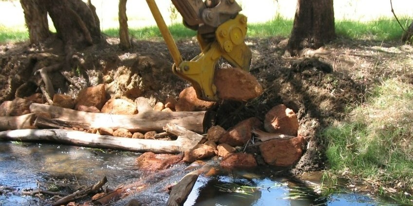
Large woody debris (dead tree trunks) and rocks are placed to stabilise an eroding bank and construct a riffle and pool to slow flow and trap sediment of the Canning River at Pioneer Park, Gosnells.
See also
Show moreWilson Inlet 10 - Role of sediments in nutrient cycling
Department of Biodiversity, Conservation and Attractions Habitat protection and foreshore management webpage for information relevant to the Swan and Canning Rivers.