Urban development can impact water resources and the environment while water constraints can affect the location, design, form and function of urban developments. Coordinated land use planning and water planning plays a role in mitigating the impacts of urban development on water resources and the environment and vice versa.
Our drainage for land use planning program focuses on:
- the consideration and implementation of drainage management requirements, with other land use planning obligations, at the different levels of land use planning
- producing policies, guidelines and information to guide the management of high (superficial) groundwater, stormwater and overland flooding to assist the implementation of State Planning Policy 2.9 - Planning for Water (WAPC 2021) and its associated guideline.
The Department of Water and Environmental Regulation is a referral agency for water aspects of land use planning proposals through state and local government agencies.
To assist with implementing this advice, we have developed the diagrammatic approach ‘Drainage Guidance for Land Use Planning’, which is based on State Planning Policy 2.9 - Planning for Water. The graphic outlines the objectives and outcomes for drainage management at each land use planning stage and links to our suite of policies, guidelines, and procedures.
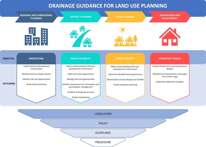
The information on each planning stage provides a summary and the resources available to assist stakeholders to achieve the outcomes.
For further information on the detailed requirements refer to State Planning Policy 2.9 - Planning for Water.
Regional and sub-regional planning
Show moreRegional and sub-regional level planning guides the development of an area in the medium to long term (five to thirty plus years). Drainage planning at this level is required to identify and map areas of natural drainage, catchment flooding, and seasonal inundation including regional scale depth to groundwater which can be used to inform land capability and underpin land use planning controls.
Objective
To understand and map the existing regional or subregional water resources and the proposed land use changes as well as the risks and opportunities to water resources from proposed changes.
An understanding of land capability, including risks and opportunities for management, early in the land planning process will lead to the development of more integrated management solutions, quicker approvals and better outcomes for the environment and future communities.
Outcomes
Understand pre-development environment
Identify key features and understand the predevelopment hydrology of the landscape through appropriate analysis. Identify and plan studies that require long lead times to complete (e.g., flood modelling, surface, or groundwater monitoring over several years).
Identify land use change impacts
Identify future land use change, including identification of suitable development in the context of the drainage resources and constraints at a regional scale including flood storage and drainage pathways
Identify risks and opportunities
Identify the impact of development on water resources and the environment. Assess the risks and opportunities to and from water resources and the environment. Identify mitigation strategies.
Guide district planning
Understanding the regional and sub-regional planning issues and matters to be resolved by future studies, including timeframes, is necessary to move with assurance to the next stage of planning. For example, undertaking any detailed monitoring and modelling to understand the predevelopment environment and what is required to manage water post-development.
District planning
Show moreDistrict-level planning guides the development of an area and should consider development at the catchment scale, even if this is beyond the planning area. Not considering water that comes from offsite has been known to create flooding and inundation issues.
Drainage planning at this level is required to identify the land needing to be set aside for water, sometimes supported by detailed hydrological or environmental studies. Stormwater and groundwater management should also be identified.
Objective
To prove the land can support the proposed land use change and that there is adequate land available for drainage management and its implementation.
Outcomes
Refine understanding of the pre-development environment
Refine the understanding of the key features and undertake a more detailed analysis of the pre-development environment, hydrology, and hydrogeology of the superficial aquifer. This includes commencing any studies with long lead times identified in the previous level of planning. (e.g. flood modelling, surface, or groundwater monitoring over several years).
Determine land requirements
Demonstrate the area can support development by identifying and documenting land to be set aside for drainage and major infrastructure (natural and constructed). This includes but is not limited to, flood storage areas, flow paths for major flooding, wetlands and their buffers, waterways and their foreshore areas or reserves, living stream corridors, discharges, and groundwater subsoil discharges. It also includes catchment drainage management for cross-boundary management to avoid cumulative impacts from staged development.
Manage risks and opportunities
Identify the impact of development on the stormwater and groundwater, receiving water bodies and adjacent catchments. Conversely, identify the impact of stormwater and groundwater on the proposed development. Assess the risks and opportunities associated with these impacts and provide strategies to address them. This includes determining any studies and investigations required to mitigate the risks or verify the opportunities.
Identify requirements for stormwater and groundwater management
The strategy for land requirements for stormwater and groundwater management should be identified following the drainage policy, principles and guidelines. This includes space-proofing areas to manage the small, minor, and major rainfall events and defining the appropriate controlled groundwater level. For high-risk areas more detailed location/sizing/design for major flow paths, flood storage areas and drainage service areas may be required. This is also where strategies are identified to deal with the risks and opportunities that have been identified.
Establish drainage governance
Identify and establish drainage governance arrangements for the design, ongoing management and construction of drainage infrastructure, including the identification of service providers and licensing requirements.
Guide local planning
Undertake adequate studies and collaboration with decision-making authorities and other state advisory agencies and put in place effective controls to avoid cumulative impacts at the subsequent planning stages. Establish a clear plan for implementation and staging of development, which ensures equitable management of drainage and flooding requirements. Ensure this is developed in consultation with the ultimate asset owner.
Local planning
Show moreLocal structure planning is a critical stage in supporting better water management outcomes. An integral part of the design process is the consideration of how the urban structure responds to the water resources onsite, stormwater, surface water and groundwater.
Local-level planning guides the development of an area in the shorter term and shows that it is feasible. Drainage planning at this level should provide proof-of-concept including detailed conceptual plans for stormwater and groundwater management and refine the land requirements for these.
Objective
Address the design objective and site conditions from earlier stages and provide enough evidence to prove that the proposed concept design functions and that controls are set for subsequent planning.
Outcomes
Refine understanding of the pre-development environment
Provide evidence to demonstrate a detailed understanding of the site-specific predevelopment environment and hydrology. Demonstrate how this evidence is used to inform the proposed conceptual design.
Determine detailed land requirements
Identify the detailed location and sizing of land for:
- major flow paths and flood storage areas
- the safe management of stormwater and groundwater to protect infrastructure and the environment
- water quality treatment of stormwater and groundwater subsoil discharges
- wetland buffers waterway foreshore areas and important vegetation particularly where they interact with flooding, stormwater management and drainage
- drainage service areas.
Demonstrate concept designs are feasible
Demonstrate the feasibility of the water management systems and strategies with plans and designs that are proposed for implementation through detailed design and delivery at subsequent planning stages. The Local Water Management Report should expand and address the matters identified in the District Water Management Report and provide site-specific evidence to support decision-making.
Guide subdivision planning
The conceptual design for the proposed drainage management systems is provided in enough detail to inform detailed design and delivery at subsequent planning stages. Any issues likely to significantly alter the design must be resolved. Confirm requirements for maintenance of proposed assets, systems, and strategies to inform future asset owners and managers.
Sub-division and development planning
Show moreSub-division planning provides a detailed framework for the development of an area. Drainage planning at this level should provide detailed designs for stormwater and groundwater management, while maintaining all previous requirements for other water aspects, such as flood storage. The development level of planning is where the development designs are implemented, along with all water management strategies.
Objective
Detailed design of drainage systems, consistent with water sensitive urban design approaches that mimic natural water cycle processes for stormwater and groundwater and with what was proposed in previous stages of planning.
Outcomes
Finalise infrastructure and maintenance designs
Detailed design for stormwater and groundwater management systems including locations, arrangements, and sizing of agreed structural and non-structural controls, any staging requirements, and temporary works/systems. Demonstrate integration with any upstream and downstream systems and provide an agreed asset maintenance plan.
Detailed land requirements unchanged from earlier stages
Land requirements are consistent with previously approved stages of planning. This includes unchanged requirements for flood storage areas and major flow paths, the safe management of stormwater and groundwater to protect infrastructure and the environment, water quality treatment of stormwater and groundwater subsoil discharges, wetland buffers, waterway foreshore areas and important vegetation, particularly where they interact with flooding, stormwater management and drainage.
Implement approved strategies
Relevant water management strategies and plans are applied and built so that the proposed development complies with all previous planning decisions/approvals.