Water management in the Esperance groundwater area
The Department of Water and Environmental Regulation is responsible for managing, licensing and protecting groundwater in Esperance.
Across the south-west corner of the state, from Geraldton to Esperance, groundwater is being affected by climate change. We take seriously the evidence of climate change and its effects on our precious groundwater resources. Groundwater is vital in Esperance as there is only one reliable fresh aquifer to supply the town and surrounding areas, the shallow Superficial aquifer.
Groundwater is used in Esperance to provide drinking water, irrigate parks, gardens, schools and caravan parks, in industrial processing, and for many other uses. It also supports the natural environment, including urban trees, wetlands and lakes.
With climate change, there is less rainfall recharging the Superficial aquifer in Esperance. Decreasing rainfall, combined with where and how groundwater is currently being taken, will cause the aquifer to become more saline if no action is taken, affecting its usability and longevity as a source for local use.
Planning is essential to make sure that our water supplies are secure for the needs of the community, future generations and the environment. Water allocation plans are regularly evaluated to review and improve management of water resources.
Our latest evaluation of the 2007 Esperance groundwater area water management plan showed that groundwater abstraction in the Town and Twilight subareas is at its limit.
The Esperance groundwater allocation plan evaluation 2012–2020 covers the evaluation of the Esperance groundwater area water management plan. The evaluation used climate modelling, water level and water quality monitoring, and metering data to evaluate the aquifer.
We are working with key licensees to continue to monitor, track and adapt our management in response of a changing climate and new information.
Esperance groundwater area
The plan covers the area defined as the Esperance groundwater area, proclaimed in 1973 under the Rights in Water and Irrigation Act 1914 (RiWI 1914) to regulate how groundwater is taken and to protect the long-term availability of groundwater. Abstracting and using groundwater in the groundwater area requires a licence.
The town of Esperance is in the groundwater area, about 725 km south-east of Perth on the Southern Ocean coastline. The groundwater area is a narrow coastal strip varying from 3–10 km wide between Lake Gore in the east and Coramup Road in the west and is about 360 km2.
The Esperance groundwater supply is protected by managing land uses and associated activities in the Esperance Water Reserve water source protection area. The reserve was proclaimed under the Country Areas Water Supply Act 1947 (CAWS Act) in 1970. Boundary realignments were made in 2001 and 2013 to ensure ongoing protection of the drinking water source. The protection boundary aligns closely with the groundwater area boundary.
Aquifers in Esperance
Groundwater used in Esperance is contained in the sedimentary aquifers of the Eucla Basin and fractured rock aquifers. The Eucla Basin is a geological formation extending the length of Western Australia’s southern coastline.
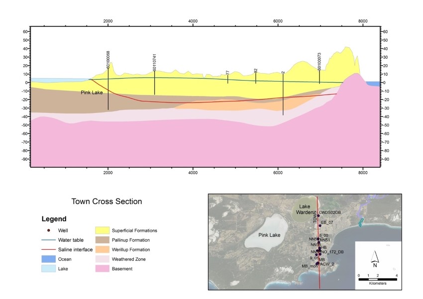
In the sedimentary aquifer, the layer closest to the surface is the Superficial aquifer. This is also the primary source of groundwater for all water users in Esperance and is crucial to supplying the town with clean drinking water. Esperance lake and wetland systems have formed where the Superficial aquifer intersects with the land surface.
Plan area
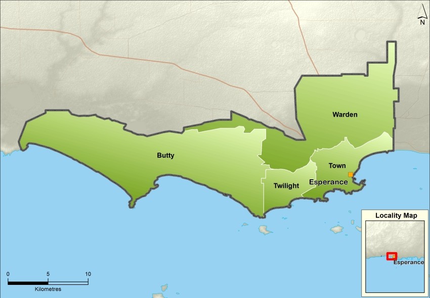
The plan covers the Esperance groundwater area. The area is divided into subareas to manage how groundwater is shared and allocated at a local scale. In 2018 we updated the subareas across the plan area to better allocate water for public and self-supply, and to address salinity impacts.
The groundwater area is now divided into six subareas – Warden, Bandy, Town, Twilight, Eleven Mile and Butty. These boundaries correspond with the geological and hydrogeological features of the area. They also reflect the response of the groundwater system to changes in water quality, abstraction and recent town developments.
Water use in the plan area
The population of Esperance relies almost entirely on groundwater for public and private water supplies.
Esperance groundwater also occasionally supplements supplies for drinking water and drought relief for the surrounding communities of Salmon Gums, Grass Patch, Condingup, Hopetoun, Ravensthorpe and Munglinup. These localities have limited fresh water, particularly during extremely dry seasons, making the Esperance Superficial aquifer very important.
Groundwater use in the plan area is mainly for:
- public water supply for the town of Esperance
- industry – abattoir and industrial processing
- irrigation of public open space and sporting grounds
- commercial irrigation – horticulture, turf and pasture production
- domestic gardens, stock watering and pasture irrigation.
The above uses are licensed, except stock watering and domestic garden use.
Publications
Esperance groundwater area water management plan
Esperance groundwater allocation plan: Evaluation statement 2012–2020
Esperance groundwater area water management plan: Evaluation statement 2007–2011
Esperance Water Reserve drinking water source protection plan