The Murray catchment drainage planning area contains land which is prone to seasonal inundation by shallow groundwater, significant flooding during major storm events and at risk of flooding from extreme tidal conditions and storm surges.
To enable development, these characteristics must be considered and managed as part of the land planning and development in this area.
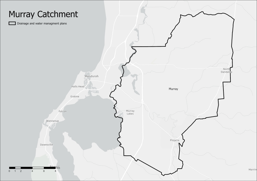
Catchment area
The Murray catchment comprises a series of inter-connected wetlands, lakes, rivers and groundwater aquifers that contribute to the highly complex and internationally important hydrological and ecological system of the Peel-Harvey estuary catchment.
The main environmental condition of the plan area, particularly during winter, is one of excess water, coupled with limited availability of allocated water resources that are traditionally considered useable.
Areas of the Murray catchment are increasingly being considered for urban development, with the Western Australian Planning Commission identifying areas for future development in the subregional frameworks.
We have prepared guidance and advice on water management for future development below.
Drainage and water management plan
As part of catchment drainage planning, we provide our stakeholders with an understanding of the movement of stormwater (flooding) and groundwater water in the landscape and its interaction with other features such as wetlands, rivers and existing drains in the context of future development.
This information is presented in the form of a drainage and water management plan (DWMP), which provides approaches to enable development while also protecting infrastructure and human safety and life.
The Murray drainage and water management plan was the first DWMP we produced and contains principles, strategies and tools to achieve the best water resource management practices for the Murray area.
Supporting technical studies
We prepare technical studies to provide an understanding of the movement of stormwater and groundwater in the catchment and to consider flood and inundation risks, and prepare flood mapping to influence better water and land use planning.
These studies provide the technical basis for the drainage and water management plan and will allow development in this highly challenging area. These reports are also used to give guidance to local and state government planning agencies.
Hydrological studies
Show moreA series of hydrological studies were completed to understand the distribution and movement of surface water and groundwater in the landscape. In particular, how the surface water interacts with the high groundwater in the area.
The scenarios determine the effects on the hydrological regime of the area for pre- and post-development conditions. The hydrological studies are presented in separate reports:
- the Murray hydrological studies: conceptual model report, which characterises the hydrology and hydrogeology of the area
- the Murray hydrological studies: land development, drainage and climate scenario report, which analyses and discusses scenario results in the context of hydrological constraints.
Flood modelling and drainage studies
Show moreThe flood modelling and drainage studies are developed at a catchment scale. The objective of these studies is to understand the flood behaviour under the existing catchment conditions before development and then assess the risks and benefits of different future development scenarios through flood mapping.
A hydrologic and hydraulic assessment is conducted for the designated catchment area. A hydrologic assessment or model assesses the runoff of surrounding and upstream catchments into the catchment of interest. The hydraulic flood model is used to simulate flood behaviour, map flood extent and determine water level and discharge at various locations.
Most major rural drains in the area are managed by the Water Corporation. Our department and the Water Corporation have shared responsibility for managing drainage and flooding in this area and work together through the Drainage for Liveability initiative.
The Ravenswood flood modelling and drainage study provides the flood behaviour and floodplain mapping of the North and South Ravenswood proposed development areas as identified in the Perth to Peel 3.5 million sub-regional frameworks. Floodplain risk management and land capability advice was provided to the Western Australian Planning Commission to assist in the determination of the land uses in the area. The report and determination is available on the Department of Planning, Lands and Heritage website. This document is available from us upon request.
Environmental studies
Show moreThe studies below provide further context to the environmental conditions in drainage planning.
These include, but are not limited to:
- The Feasibility of managed aquifer recharge using drainage water, which outlines the potential of the confined Cattamarra Aquifer for storing harvested stormwater of a suitable quality
- The Murray hydrological studies: acid sulfate soil risk assessment and hydrochemistry, which focuses on a risk assessment of acid sulphate soil disturbance resulting from predicted changes to climate, topography and drainage, and an investigation of the groundwater and wetland hydrochemistry.